This afternoon Edmonton Transit announced its recommended routes for West and Southeast LRT lines. The routes “work towards the Transportation Master Plan’s vision to expand LRT service to all sectors of the City of Edmonton by 2040.” Back in June, City Council approved the LRT Network Plan, which identifies how the LRT system will be expanded. These two routes are part of that plan.
Here’s what the recommended routes look like (click for a larger image):
There was a lot of information shared during today’s briefing, which I did my best to live-tweet. Here are some of the highlights:
- This is not the LRT you’re used to – it’s low floor technology with smaller, urban style stations.
- Initially, there are seven stations planned for the West LRT route and six for the Southeast LRT route.
- The two routes are actually part of a single line, which means you’ll be able to travel from Mill Woods to Lewis Estates without any transfers.
- Travel time from either end to downtown will be 20-25 minutes. Both speed and carrying capacity is expected to be the same as the current LRT line.
- The estimated cost for each route is between $900 million and $1.2 billion.
- Short-to-medium term ridership for each line is expected to be 45,000 riders per day by 2040.
- Though bus routes will almost certainly be eliminated, service hours will likely remain the same and will simply shift elsewhere (so in effect, the LRT is making the bus system more efficient).
- The downtown connection still needs to be considered.
The routes were evaluated based on a new set of decision-making criteria established in December 2008 for LRT route planning. Initial screening looks at feasibility, community, and environment. The next stage is the specific evaluation criteria, with weights in brackets:
- Land-use/Promoting Compact Urban Form (4)
- Movement of People/Goods (3)
- Feasibility/Construction (2)
- Parks, River Valley and Ravine System (2)
- Social Environment (2)
- Natural Environment (2)
 Recommended Route Route Options
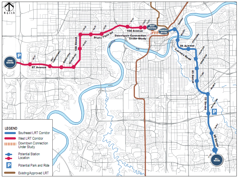
The Southeast LRT corridor travels north from Mill Woods Town Centre on 66 Street, continuing north on 75 Street. It then uses Wagner Road to extend either over or under the CP Rail line to 83 Street. From there, it proceeds along 83/85 Street north to 95 Avenue, then along 95 Avenue to Connors Road with the route crossing the North Saskatchewan River, either replacing the Cloverdale footbridge or adjacent to it, and east into downtown to connect to the proposed Quarters development, providing a surface (street level) connection to Churchill LRT station, ultimately connecting to Grant MacEwan College.
Major potential stations: Muttart Conservatory, Bonnie Doon Mall, Grey Nuns Hospital, Mill Woods Town Centre
Key benefit: Direct link to downtown, minimizes traffic impacts to Connors Road.
Key weakness: Neighbourhood disruption.
Recommended Route Route Options
The West LRT corridor goes from Lewis Estates east along 87 Avenue, then north on 156 Street. It connects to downtown via Stony Plain Road and 104 Avenue, providing a surface (street level) connection to Grant MacEwan College.
Major potential stations: MacEwan, Oliver Square, Jasper Gates, MacEwan Arts Campus, Jasper Place, Meadowlark Shopping Centre, Misericordia Hospital, West Edmonton Mall
Key benefit: Direct connection to downtown, opportunity to transform Stony Plain Road into a transit corridor for west neighbourhoods.
Key weakness: Impact on established neighbourhoods.
Discussion & Analysis
At this point, I’m simply happy to see this moving ahead. The South LRT expansion has been going well, and it’s important to keep momentum and interest. The West LRT route has definitely been the more controversial of the two, and I don’t see that changing (which likely means that the Southeast LRT route will get built first).
I talked to Councillor Kim Krushell this afternoon to get her thoughts on the recommended routes. While she too was happy to see progress, she had reservations about the West route, telling me that she didn’t necessarily agree with the weighting of the evaluation criteria. “Some estimates put the number of people working at the U of A at 50,000 and the number working downtown at 60,000. The recommended route bypasses a major employment centre.” While she’s “not against the Stony Plain route” she will be asking questions to better determine if the Stony Plain route is actually better, and admitted that “the Oliver connection is appealing.”
That got me thinking about the impact of the West LRT route on the University of Alberta. While many who work in the area may not replace their vehicles with the bus, there’s a good chance they’d use Park and Ride and take the train to work. Students on the other hand, will almost certainly use the bus if no other transit option is available. I called Students’ Union President Kory Mathewson to get his thoughts: “The biggest impact for students is access to afforable housing. The more transit connections we have to the University, the more options students have.”
I expect to see a number of community meetings and town halls related to the West LRT route over the next couple of months.
What’s next?
This is far from a done deal, and there are a bunch of upcoming events you should know about. First up are a series of public information sessions taking place on September 21 and 23 for the Southeast LRT route and September 29 and 30 for the West LRT route (full details here). This is your opportunity to learn more and to ask questions.
Next is a statutory public hearing on November 9th, followed by a report back in December 2009. Concept engineering, which includes working with individual neighbourhoods to site stations, complete environmental analysis, planning a new maintenance facility site, and further defining the downtown connection, will take place from November 2009 through December 2010. It is during the engineering phase that details like home expropriation will be determined.
Funding is in place for a Lewis Estates Transit Centre and Park and Ride facility (with over 800 parking stalls). The Transit Centre is expected to be completed in March 2010, and the Park and Ride in July 2010.
Beyond that, a lot depends on the direction and priorities set by City Council. We should get some indication of their thoughts at the Transportation Master Plan public hearing taking place on September 14.
To keep up-to-date on these and other LRT projects, visit http://www.edmonton.ca/LRTprojects.
UPDATE: Thinking about the West LRT a little further, does it matter that it doesn’t go directly to the University of Alberta? By the time it’s built, the Quesnell Bridge will be widened and express bus service from West Edmonton Mall to the U of A will likely be quite fast.

I don’t see NAIT on the West Line? Connect all three major post-secondary institutions on the LRT and then you have something really amazing.
Added to that, a major downtown facility like the arena/conference facilities and new airport lands (hopefully), plus future extension to the airport and St. Albert, and we have a 50-year foundation to fill around.
Oh, and if we’re dreaming, an integrated high-speed rail line to Calgary to create a mega-economic corridor.
IMHO
NAIT isn’t on the West line, because it’s on the NAIT line (as are the ECCA lands) – more at http://bit.ly/Is3jV. The idea at the moment seems to be that everything will converge downtown. Once the primary corridors are established, premium service will be evaluated (so that you can bypass downtown for transfers).
I’m still not convinced about the ABHSR line, btw.
One tiny quibble: it’s not ETS that recommends these locations, it’s the Transportation Department (of which ETS is one branch). I’m very pleased to see the SE choice; Those that did not flow through the Strathearn/Holyrood/Bonnie Doon area had design flaws, IMHO.
True Chris, I used ETS and Transportation interchangeably in this post, but you’re right, it’s actually Transportation that makes the recommendations.
Curious as to know how they will “make the grade” climbing out of the river valley (Muttart) up to 95 Avenue.
IIRC, Calgary had a similar issue, resolved by tunneling.
Stony Plain route argument (re-development) makes sense, but I wonder where they will transition from GMCC to 104 Avenue. The still-available CN right-of-way terminates somewhere around the old Molson’s plant.
RE: ABHSR I’m not sold either. I do think there should be a EIA high speed connector train to the the LRT at least. See Kuala Lumpur/Hong Kong/Bangkok, etc. Huge airport hubs located a fair distance away from their high density cores.
What’s wrong with transferring trains downtown to get from WEM to the UofA? Do some people want a train going through the river valley instead?
By adopting the low-floor European model and pledging to use existing traffic lanes, the transportation department has responded to some community concerns about invasiveness.
I don’t foresee people in my neighbourhood, Grovenor, or residents of Glenora or Westmount or Oliver, reacting with the same anger that emerged from Laurier Heights last year. Much of that frustration was directed at the process, not necessarily the route itself.
People in Jasper Place need to be heard. They contributed a lot of hours to generating a revitalization plan while being told LRT down Stony Plain Road was not an option. In fairness, the route should serve JP, as opposed to JP serving as the route.
The primary issue in Grovenor is creating a provision so that new transit-oriented development is not exclusively adult-living. Owing to sprawl, we lost one-third of our kids between 1996 and 2006, which makes maintaining facilities such as the school, skating rink and playground quite challenging.
Only 2.7 per cent of people living in completed redevelopment projects are school-aged children up to Grade 12. Of all kids in Edmonton, 25 per cent live in new neighbourhoods on the edge of the city with no schools. That’s #yeg’s biggest sprawl #failwhale.
LRT along Stony Plain Road needs to make this situation better, not worse — which is what happens when we decide greener, denser housing is only for adults.
Tys – I’d love to see some sort of high speed connection to EIA, even if it is just a bus.
Eric – Yeah the idea would be to go directly across the river roughly along where 87th Avenue is.
Great comments Christopher, thank you. I agree that the low-floor technology and using existing traffic lanes is a major plus.
I like the idea of using Stony Plain Road, but I had hoped the line would run on 102 Avenue and have a stop at the Museum/near High Street.
Linking Edmonton’s attractions (not just shopping and work sites) to LRT would be great for the city.
I was skeptical about the low floor trains going down 95 Ave and 83rd St until I saw a picture. Here’s a direct link to a pdf on edmonton.ca:
Click to access 200905_VehicleTechnologyReview.pdf
I know this may be a far-fetched idea, but I think it would be cool to have the Old Strathcona streetcar line integrated with this LRT plan. Have full street car service from MacEwan, down the existing streetcar line (and have an integrated Grandin LRT-Streetcar stop), and going further to the proposed Bonnie Doon stop on the SE line.
Does anyone know if there are any plans to eventually make one of the downtown stations (ie. Churchill or a new arena location) into a large transit center with many multiple transfer options? It seems like there are a lot of plans to be funneling all these people downtown, and it would make sense to have a major station that could handle and accommodate it all on a large scale. (eg. buses, LRT (new and old), ABHSR, etc., etc.)
I just don’t think any downtown stations could currently handle this.