Finding your way around downtown Edmonton is about to get easier

Walk around downtown today and you might notice some new signage. New wayfinding prototypes have been installed around Churchill Square, part of a pilot project being led by Walk Edmonton.

Edmonton Wayfinding

Each sign contains directions to nearby destinations, a map of the area the sign is located in, and information about the wayfinding project. Importantly, the directional information and the map contain time estimates for pedestrians. This should help pedestrians to orient themselves and make it to key destinations.

Edmonton Wayfinding

The Downtown CRL Plan (PDF) contains a catalyst project called Green and Walkable Downtown that refers to “a phased and coordinated program of street and public realm improvements” focused on pedestrians. It also highlights the notion of a wayfinding system:

“Wayfinding refers to the system of visual cues, such as signage and maps that people use to find destinations and navigate neighourhoods. In the downtown context, a coherent and effective wayfinding system is particularly important to pedestrians and cyclists.”

“The wayfinding signage that exists downtown today is inconsistent and in some cases incoherent or absent. There is currently a patchwork of signage systems. A Wayfinding System would include signage at street level for pedestrians. Web and mobile phone-based wayfinding tools could also be developed. All components will be well-integrated, sharing a mutual look, language, and logic that will facilitate movement.”

Edmonton’s current wayfinding is a mess. It’s a mix of different approaches, developed at different times, with no coherent system or plan. It’s not just the pedway either, it’s everything. I’m really excited to see this start to change, and just in time for what is perhaps the busiest construction period downtown has ever seen, with the LRT, arena, Royal Alberta Museum, and many other projects underway. Good wayfinding is about to become more important than ever before.

Edmonton Wayfinding

This is just a first step, and there’s lots more that could be done. I’d love to see a digital component as well, with a mobile site or apps or both. Connections could be made to ETS wayfinding, and of course, we need to fix the pedway signage!

The City is running an online survey to gather feedback on the proposed maps and signs. You have until May 4 to provide your input!

Edmonton Wayfinding Project

While the City has been working on wayfinding for a while, it was a group of interested citizens that really got things moving.

Tim Querengesser put a project up on Make Something Edmonton in March 2013. It was focused on the pedway, but it quickly attracted a group of interested Edmontonians. After a couple of meetings, they expanded their scope to wayfinding more generally.

Tim had moved to Edmonton from Toronto not long before starting the project. When he discovered the pedway he thought it was great, but found the signage to be very poor. After travelling to many large cities, he had seen plenty of examples of excellent signage. Tim figured he should try to do something about it. “In Toronto there’s a ‘don’t get involved’ culture,” he said, “but I really wanted to get involved here.”

Edmonton Wayfinding Project

Putting up a Make Something Edmonton page was all it took to get started. The group is now known as the Edmonton Wayfinding Project, and they’ve been a critical factor in the development of the City’s wayfinding effort. They’re all volunteers but they’re quite active. They have published articles on wayfinding, organized an installation at Harcourt House, have created a buzz in the media, and have met with the City numerous times to provide guidance and feedback.

There’s no question the group has had an impact. In fact, the City’s own report on wayfinding (PDF) says so:

“Wayfinding is also a topical item of conversation in the city as a result of to advocacy and projects improve use and navigation of the Pedway and River Valley Parks. The ‘Make Something Edmonton’ group are an example of grass-roots community interest that has raised the profile of wayfinding in the city.”

Have you ever wanted to change something in Edmonton but thought it was too difficult? Let this be an example of how anyone can make a difference as long as you’re willing to put in a little time and energy! It’s so exciting to see a group of engaged Edmontonians going after something they care about. Imagine what could be done if there were another dozen groups like the Edmonton Wayfinding Project!

Kudos to Tim and the entire team on your achievements thus far; keep it going! You can follow the group on Twitter at @WayfindYEG.

Edmonton’s Pedway: Wayfinding

This is the third part in a series of posts looking at the past, present, and future of Edmonton’s pedway network.

Have you ever gotten lost in the pedway? You wouldn’t be the first to do so.

In the late 1970s, the City began to think about how to make the pedway more usable, and navigational information (known today as wayfinding) was to play a big part of that. The Pedway Concept Plan of 1976 called for “a standardized information guide applied throughout the system, including directional signs, maps, route directories, and general information signs” and “identification for individual commercial frontages.”

In March 1989, the City published the Downtown Pedway Network Review which highlighted the need for improved signage. “There is a need to develop and implement a directional and information signage program for the pedway network,” it said. “The 1987 pedway user survey revealed that users generally were unaware of the extent of the pedway network beyond a few specific areas.” As is often the case with the City, there was already a project underway to improve the signage when the report came out.

Pedway Documents

In 1987 the City of Edmonton entered into an agreement with Lance Wyman Ltd. for “consulting services in the area of the design of public signage and information systems.” Wyman has had extensive experience in designing branding and wayfinding systems, having worked on the Washington D.C. Metro maps, the Mexico City Metro icons and wayfinding, wayfinding for Midtown Detroit, and branding & wayfinding for Pennsylvania Station in New York City, among many other projects.

Edmonton’s pedway wasn’t the only project Wyman undertook in Alberta. He also designed the branding and wayfinding for Calgary’s +15 network. Here’s what he wrote about it in 2004:

“Symbols can participate with the environment in many ways and can enhance and make a wayfinding system work better. A symbol can be a reminder of history and a functional directional guide at the same time. The Calgary +15 Pedestrian skywalk symbol (bridges and walkways are 15 feet above grade) combines references to the city history and culture (local native Blackfoot star constellation circles, traditional white rodeo hat symbol) to establish a symbol that participates in all aspects of the wayfinding system. Circle patterns are also used to indicate the walking path on +15 maps, and are inlaid into the floors in contrasting materials to indicate the actual walkways. The consistent use of the circle patterns become familiar +15 wayfinding information and is a reference to Calgary history.”

In Edmonton, Wyman’s work was to proceed in three phases. The first would be Preliminary Design, during which data would be collected and Wyman would become familiar with the system. A concept for the pedway system logo, typography, and symbols would also be produced in the first phase. The second phase would be focused on detailed design, resulting in a manual and cost estimates for each element. The third phase would be a demonstration project. The total value of the contract, signed in December 1987, was $117,950.00. Only the first phase at $27,725.00 was funded at first; the other two phases were to proceed subject to funding approval from City Council. The work was to be completed by the fall of 1988.

Wyman eventually produced the City of Edmonton Pedway Signing & Graphics Manual (pictured above), which outlined the pedway network logo, iconography, and other design details. “The Helvetica system of typography was chosen for the Pedway to be compatible with the LRT signing system, which also uses the Helvetica system,” it reads.

pedway levels

Something that may not be immediately apparent is that the pedway logo itself comes in three versions, one for each level of the system. As Wyman puts it, “pedway logos inform pedestrians which of three walkway levels they are on; Subway, Street, or Skywalk.”

Another unique aspect of the design are the directional elements. “The signs give orientation using compass directions that incorporate familiar city landmarks; the North Star to the North, the refineries to the East, the river to the South, the view of the Rockies to the West.”

pedway directions

The manual includes design details on a wide array of different signs, including:

  • Flag Sign (sticks out from building)
  • Wall Sign (flat on building)
  • Elevator Button Sign
  • Pedestal Map
  • Wall Map
  • Waymarker Sign (mounted at baseboard level)
  • Stencil Sign (for paint applications)
  • Overhead Sign
  • Street Name Sign
  • LRT Sign (on the illuminated signs)
  • Entrance Decal (interestingly has different times for entrance hours)

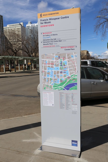
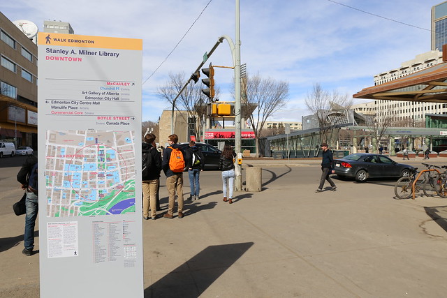
The project was a relative success, and today the signage that Wyman designed can be seen throughout the network. In 1989, the Downtown Pedway Network Review recommended that the designs and signs “be incorporated into the existing portions of the Pedway Network and used in all future pedways.” Furthermore, it recommended that all development agreements should “require installation of this standardized signage system within the pedway link and throughout adjacent developments to ensure ease of access by pedway users.”

Edmonton Pedway Signs

Over the years the signage rolled out, but it very quickly became out-of-date. As new buildings and connections appeared, they did not always follow the same format and some lacked signs altogether. There were long stretches of time during which the pedway map was not updated. Even today, the link to the Downtown Pedway Map on the City of Edmonton’s website takes you nowhere. Today’s system reflects a lack of ownership over the wayfinding aspects of the pedway, resulting in a mess of different signs and maps.

Twenty years after they first tackled the problem, Council decided to do something about wayfinding in the pedway. On November 18, 2009, Executive Committee directed Administration to work with the Downtown Business Association on addressing issues with the pedway, including “signage, way-finding, and new directions, including connections to outside streets.” An ad hoc pedway committee was formed shortly thereafter, and they identified “a system of standardized signage” as a key opportunity. The committee felt that a database should be created containing all of the relevant details about the pedway, so that it could serve as the basis for a web-based map to help people navigate the system.

Edmonton Pedway Signs

The Downtown Pedway Committee was officially established in September 2010 with a mandate to “examine and address the challenges and opportunities” related to the pedway. The committee met six times throughout 2011 and focused their efforts on updating the existing pedway maps, a task they finally completed in March 2012 (you can download it in PDF here). Next they turned their attention to wayfinding.

“The major focus of the Committee has been the creation of an integrated way-finding signage system for the pedway network. A way-finding system performs the essential function of directing, informing and supporting movements that allow public spaces and buildings to function. Such a system is key to ensuring that people can access and use pedways and the transit system efficiently, conveniently and safely. A comprehensive way-finding system involves not only clear directional signage to smooth pedestrian flows, but also includes open spaces beyond the pedway network which extend throughout the downtown, resulting in a more open, uncluttered environment. A comprehensive way-finding system also includes connecting street level activity with the existing multi-level pedway system.”

The Pedway Committee made it clear that they felt improvements to the wayfinding system were necessary, especially given all of the other projects taking place in the downtown area:

“The Pedway Committee feels the time is right to start planning for an integrated way finding signage system for the pedway and throughout the downtown. The downtown is well-positioned to take advantage of this initiative.”

In November 2012 the Pedway Committee made a presentation about the business case for a wayfinding system. They identified “at least 78 different signage types” throughout the pedway network, including 13 in the library parkade alone!

Edmonton Pedway Signs

They proposed a project with three phases to remedy the situaton. The first would be to do initial scoping and conceptual and detailed design. The second phase would focus on a pilot project, with the final phase including final design and rollout of the system beyond the pilot project area. Executive Committee was generally unimpressed with the presentation, and seemed shocked at the cost. The report estimated the cost of implementing such a project at $2 million, a figure based on similar projects that were recently implemented in Calgary and Toronto.

The source of that funding? The report recommended that the project be aligned with the “Green and Walkable Streets” project proposed as part of the downtown CRL. Unfortunately, when Council approved the list of catalyst projects that would be funded under the CRL on May 8, 2013, they broke Green and Walkable Streets into two. The first part, around the arena, was in the “recommended for initial funding” category. The second and much larger part, which includes any potential wayfinding project, was placed in the “to proceed on revenues actually realized” category. In other words, any improvements to the wayfinding system used throughout the pedway are for now dependent on the arena going ahead and the CRL being successful. Improvements may never happen.

So we’re stuck with the same old pedway signage and out-of-date information that has plagued downtown for the past twenty years. We’re stuck with PDF maps instead of mobile apps and other technological advances. And the situation could get even worse with the new arena, Royal Alberta Museum, and numerous other projects being constructed downtown with pedway connections.

It’s important to remember that wayfinding is about more than just signs. “An effective wayfinding system can be a visual ambassador, a means of saying ‘Welcome, let me help you find your way around and enjoy yourself’,” Lance Wyman wrote in 2004. “Wayfinding offers the designer an opportunity to reference the history, culture, and essence of place in an immediate way that will be seen and used on a daily basis.”

Edmonton’s Pedway: The Growth Years

This is the second part in a series of posts looking at the past, present, and future of Edmonton’s pedway network.

The pedway system we know today was largely built in the 1980s. According to the Edmonton Journal in 1990, projects with an estimated value of $679 million were completed between 1983 and 1989 downtown, including $20 million on Jasper Avenue, Rice Howard Way, and the pedway system.

One of the biggest projects was the extension of the LRT line, with construction on Bay and Corona stations beginning in 1980. Subterranean downtown Edmonton must have seemed like paradise in those days, because the LRT construction had an extremely large impact on downtown. Jasper Avenue was under construction for years, and that harmed businesses as much if not more than West Edmonton Mall (which first opened in 1981).

LRT Construction 1980s
Downtown construction, photo by ETS

It wasn’t just the LRT being built though. Of the roughly 40 buildings downtown connected to the pedway, half were built between 1974 and 1984. More buildings were constructed in Edmonton during the 70s than any other decade. It’s no surprise then that the pedway grew significantly during the latter part of this period and in the years immediately following it (as pedway construction tended to lag building construction).

Following the completion of Edmonton Centre in 1974, a series of office towers followed. TD Tower opened in 1976, with the Sutton Place Hotel (Four Seasons Hotel) and 101 Street Tower (Oxford Tower) following in 1978. All three had connections to the pedway built. The Citadel Theatre and Sun Life Place also opened in 1978, and the Stanley Milner Library, constructed in 1967, was first added to the pedway network that year. Canadian Western Bank Place, HSBC Place, and the Standard Life Building all opened in 1980. ATCO Centre and Enbridge Place opened in 1981, followed by Bell Tower and Scotia Place in 1982. Manulife Place and the Shaw Conference Centre opened in 1983. Canada Place capped off a busy period of construction in 1986.

Pedway connections were often added years after a building was first completed. Scotia Place was connected via an above-ground bridge in 1990 when Commerce Place (Olympia & York) opened (though it already had an below-ground connection). The Royal Bank Building, built in 1965, didn’t get a pedway connection until April 1993, one month after an above-ground pedway was built connecting Manulife Place and Edmonton City Centre (Eaton’s Centre). Construction of these connections did not always go smoothly. The bridge connecting City Centre and Manulife was delayed for a variety of reasons, but one was that the hallway from City Centre did not line up with existing “knock-out” panels that Manulife Place had for future pedway construction. That meant blasting through a wall that was not designed to be opened. Still, the bridge came in at a relatively inexpensive $200,000 (the typical above-ground bridge could cost up to $500,000 at the time).

Downtown Pedway c. 1980
Existing & Approved pedway connections, ~1980

Downtown wasn’t the only place pedway-like connections were being built. A $64 million renovation of the Alberta Legislature grounds took place from 1978 to 1982, and one of the key features was an extensive underground pedway system. In the spring of 1985, the Business Building opened on the University of Alberta campus with an above-ground connection to Tory and HUB Mall. It would eventually be connected to the larger system in August 1992 when the University LRT Station opened featuring a below-ground connection to the Dental-Pharmacy Centre and above-ground bridge to HUB Mall.

Though connections continue to be added today, many Edmontonians considered the pedway “complete” in 1990 after two key projects. The first was the extension of the LRT to Grandin Station in 1989, finally linking the downtown pedway network with the Legislature pedway network. The second was much more controversial.

The pedway linking Edmonton Centre and Churchill LRT Station was often called “the final link” in the pedway network. When the City first put the project out for tender, no bid came in at the budgeted amount of $4.9 million. The lowest bid was 14% higher, bringing the cost to $6.2 million. The original design called for a glass wall and an amphitheatre under Churchill Square, in addition to the removal of 16 elm trees. Council requested that the design be tweaked and re-tendered. That delayed the project, but the plan worked. The pedway we know today was designed by MB Engineering Ltd. and constructed by Chandros Construction Ltd., right on the original $4.9 million budget.

Edmonton Centre contributed $600,000 of the budget, and insisted on the skylights and planter boxes. Jim Charuk, Edmonton VP of Oxford Development Group, said at the time that anything less would have become a “people sewer.” The pedway connection first opened for Christmas shoppers on December 14, 1990. It closed during January 1991 so that finishing touches could be put on the project. The pedway officially opened to the public on February 18, 1991.

With the addition of City Hall in 1992, the Winspear Centre in 1997, and the Art Gallery of Alberta in 2010, the downtown pedway network has continued to grow. But today’s network was largely built in the 80s, and it shows.

Edmonton’s Pedway: The Beginning

This is the first part in a series of posts looking at the past, present, and future of Edmonton’s pedway network.

For nearly 40 years Edmonton’s pedway system has been a fixture downtown. The maze of pedestrian walkways built above streets, through parkades, and under buildings has hosted parades, buskers, and even a pop-up restaurant over the years. It has kept office workers from having to step into the rain or snow, and it has served as an emergency shelter for our city’s most vulnerable during cold spells. Thousands of Edmontonians use the system each and every day, and while not universally loved, most Edmontonians can’t imagine our downtown without it.

Elevated walkways and other pedestrian-oriented urban planning concepts were becoming increasingly common in the 1960s in North America. Cities such as Chicago had started a pedway network as early as 1951. In Canada, Toronto led the way with PATH in 1959, followed just three years later by Underground City in Montreal. Eventually the idea moved west, and both Edmonton and Calgary started exploring the concept of a pedestrian circulation network in the late 1960s.

City Council paved the way for the pedway in Edmonton by approving the following recommendation on April 8, 1968:

“Council accepts the principle of a Downtown Pedestrian Circulation System as a guide to the future planning of pedestrian circulation in this area.”

Increasing concern about pedestrian safety played a key role in the recommendation, though it would be six years before the plan to separate pedestrians from vehicles became real. A working paper on the Downtown Pedestrian Circulation System published in 1980 offered this explanation: “Unlike streets, pedways cannot be laid out, constructed, and await development to occur around them.” The pedway has never had a master plan because no one owns it. Passages cannot be built until there are developments to connect, which makes the pedway a cooperative effort between a variety of developers, including the City.

Edmonton Centre opened in early 1974, and with it came Edmonton’s first pedway connections. It was the city’s first full-block development, and it featured both above-grade and below-grade pedways. The first above-grade pedway connected Edmonton Centre with the 14-level parkade across 102A Avenue. Connections were later added to Eaton’s (now City Centre West) and the Four Seasons Hotel (now Sutton Place).

Brand new Edmonton Centre 1974
Pictured top-left is Edmonton’s first above-ground pedway, photo of microfilm by Darrell

Over the summer of 1974, Council approved the City of Edmonton Transportation Plan Part 1. The document proposed “an enclosed walkway system” for the downtown and was an important step in the development of the pedway network.

That same year construction began on the LRT. Council had first endorsed the concept of a rapid rail transit system in 1968, and through a series of reports and debates the decision to go underground was made. That presented the challenge of ensuring smooth access from the street to the trains. To tackle it, the City approved a series of development agreements with nearby properties, and started building “climate-controlled linkages” which quickly became known as pedways.

In July of 1977, Council adopted the Pedway Concept Plan with the following motion:

“That the policy guidelines contained in the Pedway Concept Plan be adopted for future planning, design, security, maintenance, financing, operation, and implementation of a pedway network for Downtown Edmonton.”

According to the plan, the City had made “substantial investments to encourage construction of the pedway system” throughout the 1970s. However it also signaled that as acceptance of pedways increased and the network was built out, the City would no longer contribute financially. The pedway would have to evolve without the direct backing of the City.

The LRT began regular service on April 22, 1978, with Central and Churchill Stations all but guaranteeing the pedway would play a key role in moving people throughout Edmonton’s downtown for years to come.

Construction hoarding in Edmonton’s downtown is a disaster

There’s a lot of construction taking place downtown, and that can mean closures, detours, and delays. For the most part, I’m willing to live with some short-term pain because I know it’ll bring long-term gain. But if you think construction downtown is bad now, brace yourself. It’s going to get much worse with the Valley LRT line, the arena, the new RAM, new condo and office towers, and much more. The City needs to do more to ensure it all goes as smoothly as possible.

One big issue that we should be able to do something about is hoarding (the temporary fencing you see around construction sites). At the moment, construction hoarding downtown is a disaster.

Here’s what 101 Street looks like thanks to the demolition of the Kelly Ramsey building:

Kelly Ramsey Construction

Here’s what it looks like on Rice Howard Way:

Kelly Ramsey Construction

They’ve taken the sidewalk and one lane on either side. It has been like this for weeks now.

Over on 104 Street, here’s what the Fox Tower construction looks like:

Fox Tower Construction

As you can see they’ve taken not only the sidewalk but one lane of traffic too. Yet on the alley side, they don’t appear to have needed any extra space:

Fox Tower Construction

I would have praised the Ultima Tower construction, as they have kept the sidewalk open complete with a bus stop, but their temporary closure (from May 24 to June 29) is just as bad as the others:

Ultima Tower Construction

You can’t actually see that the sidewalk is closed until you get near the site, so you know what happens right? People walk on the street, right in traffic:

Ultima Tower Construction

Hardly safe! Hopefully they’ll be back to normal next week, with the sidewalk and bus stop open.

All of these examples share some common problems. First and foremost, pedestrian access has been disrupted, and in some cases, vehicular access too. Secondly, signage is either non-existent or very poor. All have been in place for weeks or even months, with no indication about whether or not they are temporary or permanent until the projects are done. And of course, all are quite unattractive.

The Downtown Edmonton Community League (DECL) has already raised concerns with the City regarding the Fox Tower construction. They were initially concerned about the loss of trees, but when it became clear that the sidewalk would be closed with no clear timetable for it to reopen, they brought those concerns to the table as well. Thus far the response has been lukewarm at best. I understand that Graham Construction has not indicated a willingness to change anything. Worse, the City’s response was that the development would bring hundreds of new residents to the street, as if that made up for the impact on the hundreds of residents who already live here. We must do better!

Aren’t there rules?

As great as the Capital City Downtown Plan is, it lacks any real guidelines for construction hoarding. Here’s what it says:

Ensure that construction hoarding in the Downtown features a minimum functional clearance of 2.15 metres continuous linear electrical illumination and public art if in place for over 1 year, to provide a safe, clean and professional appearance.

We missed an opportunity to really strengthen the requirements through that document. There’s also the Procedures for On-Street Construction Safety document, but it mentions hoarding just once, and only as a way to “ensure that there is no danger to pedestrians from above.” Finally, there’s a section of the City’s website devoted to Design & Construction Standards, but those documents do not mention hoarding either.

If you search long enough, you’ll eventually come across Bylaw 15894, the Safety Codes Permit Bylaw. Part 1, Section 13 requires that any hoarding placed on a highway (street, lane, road, alley, etc., including sidewalks and any other land between the property lines adjacent) requires a permit. Section 14 outlines the hoarding regulations. Section 15 basically states that there must be a walkway for pedestrians approved by the City Manager. Part 7 outlines hoarding permit fees.

So in theory, the construction projects mentioned above needed to obtain a hoarding permit from the City, and must pay ongoing fees for as long as the hoarding is in place. I say in theory because, if you read the regulations, it’s clear they are not being met. So who knows if the City actually polices this kind of thing. Maybe they just approve each application without too much consideration. And though the Alberta Building Code isn’t mentioned, presumably the construction site hoarding requirements from subsection 8.2.1 also apply. But the bottom line is the City can approve whatever they like.

What happens elsewhere?

Compare all of that to Calgary, which has produced the Practical Guide for Construction Sites. It has an entire section on construction hoarding, which includes this passage:

As pedestrian flow is vital to downtown and neighbourhood vibrancy and operations, The City of Calgary Roads hoarding policies, fees and fines are intended to improve pedestrian mobility, provide effective hoarding solutions and visually enhance construction sites in Calgary. Where required, hoarding provisions must be maintained at all times for the safe passage of pedestrians in and around construction sites. In an effort to add to Calgary’s visual appeal, The City is encouraging an Enhanced Screening Initiative for hoarding applications and offers incentives for this option.

The document goes on to outline requirements for fencing and sidewalk maintenance, citing appropriate sections of the Alberta Building Code. It very clearly states that developers must “keep sidewalks adjacent to construction sites clear of obstructions” and also that they must “maintain publicly accessible and safe sidewalks.” Straightforward and to the point. On top of that, they’re offering a discount on the fees! If developers take part in the Community Boardworx Project, intended to add visual interest and public art to construction sites, they’ll receive a 25% reduction in hoarding fees!

My experience in places like Toronto and Vancouver has always been pretty positive. Oh there’s lots of scaffolding, but at least pedestrian access was maintained. It’s not all rosy though. Here’s an article from January talking about construction site nightmares in Toronto:

The current building boom has created a checkerboard of downtown curb lane and sidewalk closures. Some three dozen construction sites, mostly condo towers, are ringed with hoarding that extends over the sidewalk and curb lane, many on major streets including Yonge and Adelaide.

Politicians there have made some great suggestions as a result. Requiring developers to file construction staging plans upfront, charging higher fees the longer the closure goes on, and putting construction trailers on top of hoarding (as they do in New York) are all possibilities. There’s a lot we could learn from other cities.

Let’s be good neighbours

Downtown, like every other neighbourhood, is shared. By residents, employees, students, and yes, construction sites. When construction sites pop up in the neighbourhood, I’d like to see greater thought given to how that site will be a “good neighbour”. We’ve all got to get along. Construction hoarding, as the interface and barrier between the site and users of the sidewalk and street, is very important. At the moment, most downtown construction sites are not being very neighbourly. I’d like to see that change, and I think it must change if we’re going to make it through the next few years of construction mayhem.

LRT Construction Downtown: Short-term pain, long-term gain!

I’m excited about the expansion of our LRT network and what it’ll mean for Edmonton. It’s going to take a while until the entire network is completed, but work is already underway. While I would definitely fall into the YIMBY camp on LRT construction, that doesn’t mean there aren’t annoyances along the way. I just keep reminding myself – short-term pain, long-term gain!

The North LRT to NAIT is a 3.3 km extension from Churchill Station to NAIT with a total estimated cost of $755 million. Construction began in 2011 and over the last couple of years there has been a lot of activity along 105 Avenue and 105 Street in particular. The new line runs right through Sharon’s route to work, so she has experienced first-hand the inconveniences caused by the construction. The City has been proactive about meeting with affected stakeholders, and they even have an interactive map online, but that doesn’t completely make up for the ongoing issues.

North LRT to NAIT Construction

Closures might mean a slightly different route for motorists or a few extra minutes of travel time, but the impact on pedestrians is often much larger. Closed sidewalks can mean large detours into unfamiliar and poorly marked territory. When it’s cold out, a few extra minutes in a vehicle isn’t such a big deal but for a pedestrian it can be (and that makes jaywalking an attractive option). You’re also much more likely to find signs for vehicles than you are for pedestrians. Other issues include construction noise and, thanks to our up-and-down weather, treacherous and messy conditions.

North LRT to NAIT Construction

The new extension is slated to open in April 2014. Short-term pain, long-term gain!

The Central Station LRT Rehabilitation is a renewal rather than an extension. It will repair issues with the roof and ensure the station is functional for years to come. The City is also taking the opportunity to make streetscape improvements to Jasper Avenue between 100 and 102 Street. I work in the Empire Building at Jasper Avenue and 101 Street, which is basically ground zero for the project (and there’s also the First & Jasper construction right across the avenue).

Central LRT Station Construction

The construction team has been good at keeping everyone in the area up-to-date, with notices in the mail and electronic updates delivered through our property manager. That doesn’t mean the daily maze is any less annoying, however. I try to go through the back of the building to avoid the mess altogether, but every few days I need to use the front entrance for some reason, and determining how to navigate through the ever-changing array of fences gets old fast. There’s always construction noise to deal with too, though thankfully there have only been a few occasions when it has been disruptive.

Central LRT Station Construction

I know that travelling down 101 Street for vehicles sucks because traffic moves so much slower through the construction, but at worst you’re looking at a few minutes of delay. Compare that to the impact on pedestrians. Walking from the Empire Building to Scotia Place used to take a few seconds, we’re talking probably 30 steps or so. Now because of the fencing and detours, it takes probably ten times that! That’s a significant impact (though a little extra walking never hurt anyone).

The project isn’t expected to be complete until October 2013. Short-term pain, long-term gain!

Megaprojects aren’t enough to revitalize Edmonton’s downtown

Edmonton’s downtown has been the centre of attention lately, with a number of exciting megaprojects making headlines in recent weeks. As someone who has bought into the “as goes your downtown, so goes your city” mantra, I think the progress is good. But I firmly believe we need more than megaprojects to turn downtown around, and I’m not sure the little things that will positively impact downtown get the attention they deserve and require.

Downtown Panoramic

The most talked about megaproject is of course the $450 million arena:

“I’m elated. This is, to my mind, the start of a dream come true to rebuild our downtown.”
– Mayor Mandel, City of Edmonton and Katz Group reach arena deal (Archive)

Another megaproject is the $340 million Royal Alberta Museum:

“The aspirations of the city to revitalize its downtown, complete (with its) arts district, meshed with the province’s need for a new home for the Royal Alberta Museum.”
– Premier Stelmach, Royal addition to downtown (Archive)

Yet another megaproject is the $275 million redevelopment of the Federal Building:

“A different type of downtown? Step by step, piece by piece, we’re putting the puzzle together.”
– Paula Simons, Federal Building quietly takes shape (Archive)

Another one is the City Centre Airport, which Jim Taylor talked a lot about at the DBA luncheon yesterday. There are lots of other headlines and articles related to these megaprojects, and all seem to convey the message that collectively the megaprojects will revitalize downtown. Or that interest in downtown as a result of these projects is enough. But for these megaprojects to return the fullest return on investment possible, we need to do more. We need to make many, many smaller improvements in conjunction with the big ones. We can’t forget the little things!

To me, increasing the number of downtown residents is the key to downtown revitalization. We need a good mix of residential densities, types, and uses in the core. And we need more of the people who work downtown to choose to live there as well. Just having a new arena or museum isn’t going to be enough to get people to make that choice.

Mini-Edmonton
Photo by Jason Bouwmeester

The good news is that there are lots of small things we can do to make downtown a more attractive place to live, work, and play. Here are ten ideas that I have been thinking about, in no particular order:

  • Relax jaywalking laws downtown. I’ve had colleagues from London visit and they’re shocked that people wait at red lights! There and in many other cities, pedestrians are free to cross whenever the street is clear. I will readily admit that I cross the street on red lights all the time when the coast is clear. I think we need to make downtown a better place for pedestrians. It might seem like that’s what jaywalking laws are meant to do, but I think they actually reinforce the idea that vehicles have the priority instead. We need vehicles to slow down, and to come second to pedestrians.
  • Add scramble intersections. These are the intersections where traffic stops in all four directions, allowing pedestrians to cross the street in any direction, including diagonally. Again this helps to make downtown a more walkable, friendly place for pedestrians. This has been suggested for inclusion in the Jasper Avenue New Vision revitalization project, but we need to ensure it happens.
  • Prioritize downtown street cleaning. As soon as the snow is gone, the streets downtown should be cleaned. First impressions make a difference, and visitors are not impressed when they step outside and find themselves in a huge cloud of dust and gravel.
  • More projects like Todd Babiak’s Interventions and the Alley of Light. We need to make better use of underutilized spaces, and we could definitely do with some additional color and flair downtown. Let’s treat more of our blank walls and empty parking lots as canvases ready to be put to use. Maybe we need a community-edited database of available spaces?
  • Make public art a priority. Related to the previous point, development projects are supposed to include funding for public art, but the rules are not enforced. Capital Boulevard is moving ahead without funding for public art, for example.
  • Improve transit information displays. Downtown is already our primary hub for transit, and that role is going to be reinforced by the LRT expansion, particularly with the Downtown LRT Connector. Let’s add digital display boards to the big bus stops. They could use scheduled information for now, and be switched over to live GPS data when that system goes live across ETS. Let’s make the experience of using transit downtown even better than it already is.
  • Get rid of the portable toilets and add permanent ones. Having a place for people to go is better than having no place at all, without question. But why half-ass it? Let’s spend the (relatively small amount of) money to add permanent toilets downtown. There are lots of examples to draw upon, such as the beautiful and highly-effective public urinals that Matthew Soules Architecture designed for Victoria.
  • Add recycle bins alongside garbage cans. You may have seen the nice, silver receptacles that combine garbage, paper, and bottle recycling around the city, but there aren’t many downtown (aside from Churchill Square). We’re already a pretty green city, and this would help drive that message home downtown.
  • Require green roofs on new developments. They’ve done it in Toronto, why not here? There are many, many benefits that come from green roofs. And hey, we’ve already got one thanks to Williams Engineering.
  • Get rid of parking minimums throughout downtown. There’s a five-year pilot project in place for the warehouse district, but I think it’s a no-brainer. If you can sell a condo or rent a space without parking, then why not do it? Otherwise we’re effectively just subsidizing vehicles. This is a good way to spur development and hopefully infill, considering that it can cost developers between $30,000 and $70,000 per stall to create.

I’ve got my share of “bigger” ideas as well, such as doing whatever it takes to make the space behind the Stanley Milner library a proper usable square, perhaps alongside a larger revitalization of the building. Another one would be closing Rice Howard Way to vehicles and extending it to the top of the river valley.

I’m sure I’m just scratching the surface with this list, but the point is that there’s a lot more that goes into downtown revitalization than megaprojects. What are your ideas?