Wayfinding in Edmonton inches forward

At Executive Committee today, Councillors discussed a report which outlined why wayfinding is important, a strategy for moving it forward, and initial implementation options and costs.

Edmonton has very little wayfinding information for citizens or tourists and what we do have is confusing and lacks consistency. It has become clear that our city’s haphazard implementation of wayfinding within the pedway system is a disaster and is a mistake we should not repeat. The City’s push to see Edmontonians shift transportation modes is another big reason to support this initiative – finding your way around can be difficult if you’re not in a car. As Edmonton grows and attracts both more residents and visitors, the problem is only going to get worse. And like most things, the longer we wait to do the work required, the more it’ll probably cost.

wayfinding

The good news is that the City seems committed to doing something with wayfinding in a coordinated, strategic way. Administration understands and has articulated the benefits of wayfinding. The risk is that the funding to do it right may not be available.

Here’s an audio overview of today’s meeting & news:

You can download the cloudcast here.

Hooray for citizen action!

Would the City have come around to this position without citizen action? Perhaps eventually. But without question, the work of the Edmonton Wayfinding Project has had a significant impact. They’ve engaged citizens, they’ve conducted surveys and have done some other public engagement work, they have connected with experts in other cities, and they have pushed for collaboration with City Administration. Perhaps most importantly, they’ve shone the light on a topic that could have easily been ignored, and for no reason other than they want to make Edmonton a better place to live and visit.

The founder of the project, Tim Querengesser, was at Council today to speak to the report and to make his group’s case for the importance of progressing this work. The group published a discussion document today as well, which concluded:

“The Edmonton Wayfinding Society recommends City Council support the reports it is examining and follow their recommendations, with one caveat. The Society recommends the City reconfigure the roadmap toward a unifying wayfinding system for Edmonton to include the pedway/LRT system. Further, the Society recommends that its volunteer-driven research suggests a comprehensive study of pedway users, attitudes and behaviours is badly needed to create a wayfinding system that works in all nodes of Edmonton’s transportation infrastructure. In the interim, the Society also recommends that Edmonton introduce, immediately, guidelines for all new developments that add wayfinding as a factor that is examined. “

Be sure to follow @WayfindYEG on Twitter for updates.

Concern about costs

Today’s report included both a business case and a detailed strategy. The two hefty documents (a combined 97 pages) provide all of the necessary background and detail that you could hope for. The opening paragraph of the business case highlights one of the big problems with wayfinding efforts in Edmonton in the past:

“There have been several attempts to create a corporate wayfinding program in the City of Edmonton which have failed at the value for money decision. While it is understood generally that wayfinding offers many benefits to a growing city, it has not so far obtained support as a priority for the investment needed for citywide implementation.”

Cost dominated much of the discussion today too. Councillor Oshry in particular peppered Administration with questions about the cost of implementation, and argued after the meeting that we don’t need “the Buckingham Palace version of the signs.” He told the Sun that the proposed wayfinding strategy “seems excessive”. Mayor Iveson, however, said “to cheap out on these signs is probably a mistake.”

The overall cost of implementing the wayfinding strategy is estimated at around $10 million. That includes the development of signs, apps, plans, artwork, and more. It also includes the rollout of hundreds of physical signs. A big chunk of that cost, $5.5 million, is for the installation of maps at each existing LRT or transit station. Options for funding the project include: direct funding, which Council would need to approve; incremental funding, which would mean signs only appear as projects are completed; and revenue generation, which could be from sponsorship or advertising. Rollout options were also discussed, such as focused on downtown first and other areas later.

The business case concludes that “a pedestran-focused wayfinding system in Edmonton offers a positive benefit to cost proposition” and that “wayfinding has been shown to be a cost-effective means to overcome barriers to modal shift, a way to improve the local economy and a contributor to overall city liveability.”

Design standards

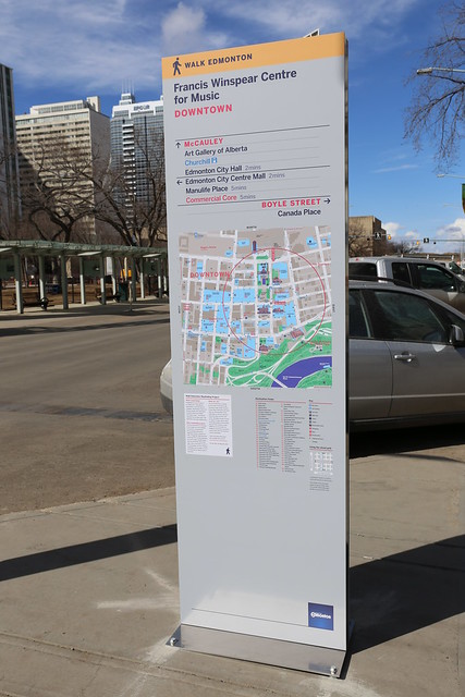
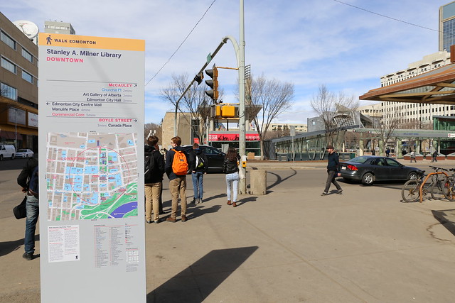
A lot of design work has already been done, which you can see in the report but also in the prototype signs that were installed around Churchill Square back in April. Future signs will include both “Walk Edmonton” and the City of Edmonton brand, and they’ll likely look a bit different than the prototype signs based on feedback and other lessons.

wayfinding

Icons are meant to be based on national or international standards, to ensure widespread recognition. The Benton Sans typeface is proposed for use across maps and signs, because it has good legibility at both large and small sizes, comes in a wide range of weights, and is a little more unique than Helvetica or other commonly used typfaces.

wayfinding

Consideration has already been given to colors, themes, cartographic elements (like the “you are here” markers), 3D landmarks, and incorporating the pedway.

Governance and maintenance

There was some discussion today about the need for a wayfinding czar, or as the detailed strategy calls the position, a “Wayfinding System Manager”. Harry Finnigan, who worked on wayfinding in Winnipeg and who spoke at Council today, said he wished they had implemented a similar position in Winnipeg. Ultimately though, Administration today decided they would rather have a team of people take responsibility for wayfinding, and Council didn’t push the point.

wayfinding

On the topic of maintenance and operations, the strategy identifies the importance of both a procurement strategy to efficiently buy and maintain signage, and an asset management database, to record information about each sign. That database of information is sorely lacking from the pedway system currently, and would certainly be important to have going forward.

The wayfinding strategy will be managed by Walkable Edmonton, under the Walk Edmonton brand. ETS and Great Neighbourhoods are the two main internal partners. Mayor Iveson also suggested that the Edmonton Design Committee be involved.

What’s next?

To some degree, the City is going to move ahead with its efforts to develop the corporate wayfinding program. At some point however, more funding will be required. There are four capital profiles being recommended for funding in the proposed 2015-2018 Capital Budget, which is when we’ll likely hear about wayfinding next. If those four profiles were funded, that would enable the City to complete roughly 60% of the wayfinding strategy.

That means Edmontonians need to keep pushing for wayfinding if they think it is important! Tell your Councillor if you want to see more funding go into this important project.

For more on wayfinding, check out the City of Edmonton’s website here and the Edmonton Wayfinding Project here.

Finding your way around downtown Edmonton is about to get easier

Walk around downtown today and you might notice some new signage. New wayfinding prototypes have been installed around Churchill Square, part of a pilot project being led by Walk Edmonton.

Edmonton Wayfinding

Each sign contains directions to nearby destinations, a map of the area the sign is located in, and information about the wayfinding project. Importantly, the directional information and the map contain time estimates for pedestrians. This should help pedestrians to orient themselves and make it to key destinations.

Edmonton Wayfinding

The Downtown CRL Plan (PDF) contains a catalyst project called Green and Walkable Downtown that refers to “a phased and coordinated program of street and public realm improvements” focused on pedestrians. It also highlights the notion of a wayfinding system:

“Wayfinding refers to the system of visual cues, such as signage and maps that people use to find destinations and navigate neighourhoods. In the downtown context, a coherent and effective wayfinding system is particularly important to pedestrians and cyclists.”

“The wayfinding signage that exists downtown today is inconsistent and in some cases incoherent or absent. There is currently a patchwork of signage systems. A Wayfinding System would include signage at street level for pedestrians. Web and mobile phone-based wayfinding tools could also be developed. All components will be well-integrated, sharing a mutual look, language, and logic that will facilitate movement.”

Edmonton’s current wayfinding is a mess. It’s a mix of different approaches, developed at different times, with no coherent system or plan. It’s not just the pedway either, it’s everything. I’m really excited to see this start to change, and just in time for what is perhaps the busiest construction period downtown has ever seen, with the LRT, arena, Royal Alberta Museum, and many other projects underway. Good wayfinding is about to become more important than ever before.

Edmonton Wayfinding

This is just a first step, and there’s lots more that could be done. I’d love to see a digital component as well, with a mobile site or apps or both. Connections could be made to ETS wayfinding, and of course, we need to fix the pedway signage!

The City is running an online survey to gather feedback on the proposed maps and signs. You have until May 4 to provide your input!

Edmonton Wayfinding Project

While the City has been working on wayfinding for a while, it was a group of interested citizens that really got things moving.

Tim Querengesser put a project up on Make Something Edmonton in March 2013. It was focused on the pedway, but it quickly attracted a group of interested Edmontonians. After a couple of meetings, they expanded their scope to wayfinding more generally.

Tim had moved to Edmonton from Toronto not long before starting the project. When he discovered the pedway he thought it was great, but found the signage to be very poor. After travelling to many large cities, he had seen plenty of examples of excellent signage. Tim figured he should try to do something about it. “In Toronto there’s a ‘don’t get involved’ culture,” he said, “but I really wanted to get involved here.”

Edmonton Wayfinding Project

Putting up a Make Something Edmonton page was all it took to get started. The group is now known as the Edmonton Wayfinding Project, and they’ve been a critical factor in the development of the City’s wayfinding effort. They’re all volunteers but they’re quite active. They have published articles on wayfinding, organized an installation at Harcourt House, have created a buzz in the media, and have met with the City numerous times to provide guidance and feedback.

There’s no question the group has had an impact. In fact, the City’s own report on wayfinding (PDF) says so:

“Wayfinding is also a topical item of conversation in the city as a result of to advocacy and projects improve use and navigation of the Pedway and River Valley Parks. The ‘Make Something Edmonton’ group are an example of grass-roots community interest that has raised the profile of wayfinding in the city.”

Have you ever wanted to change something in Edmonton but thought it was too difficult? Let this be an example of how anyone can make a difference as long as you’re willing to put in a little time and energy! It’s so exciting to see a group of engaged Edmontonians going after something they care about. Imagine what could be done if there were another dozen groups like the Edmonton Wayfinding Project!

Kudos to Tim and the entire team on your achievements thus far; keep it going! You can follow the group on Twitter at @WayfindYEG.

Edmonton’s Pedway: Wayfinding

This is the third part in a series of posts looking at the past, present, and future of Edmonton’s pedway network.

Have you ever gotten lost in the pedway? You wouldn’t be the first to do so.

In the late 1970s, the City began to think about how to make the pedway more usable, and navigational information (known today as wayfinding) was to play a big part of that. The Pedway Concept Plan of 1976 called for “a standardized information guide applied throughout the system, including directional signs, maps, route directories, and general information signs” and “identification for individual commercial frontages.”

In March 1989, the City published the Downtown Pedway Network Review which highlighted the need for improved signage. “There is a need to develop and implement a directional and information signage program for the pedway network,” it said. “The 1987 pedway user survey revealed that users generally were unaware of the extent of the pedway network beyond a few specific areas.” As is often the case with the City, there was already a project underway to improve the signage when the report came out.

Pedway Documents

In 1987 the City of Edmonton entered into an agreement with Lance Wyman Ltd. for “consulting services in the area of the design of public signage and information systems.” Wyman has had extensive experience in designing branding and wayfinding systems, having worked on the Washington D.C. Metro maps, the Mexico City Metro icons and wayfinding, wayfinding for Midtown Detroit, and branding & wayfinding for Pennsylvania Station in New York City, among many other projects.

Edmonton’s pedway wasn’t the only project Wyman undertook in Alberta. He also designed the branding and wayfinding for Calgary’s +15 network. Here’s what he wrote about it in 2004:

“Symbols can participate with the environment in many ways and can enhance and make a wayfinding system work better. A symbol can be a reminder of history and a functional directional guide at the same time. The Calgary +15 Pedestrian skywalk symbol (bridges and walkways are 15 feet above grade) combines references to the city history and culture (local native Blackfoot star constellation circles, traditional white rodeo hat symbol) to establish a symbol that participates in all aspects of the wayfinding system. Circle patterns are also used to indicate the walking path on +15 maps, and are inlaid into the floors in contrasting materials to indicate the actual walkways. The consistent use of the circle patterns become familiar +15 wayfinding information and is a reference to Calgary history.”

In Edmonton, Wyman’s work was to proceed in three phases. The first would be Preliminary Design, during which data would be collected and Wyman would become familiar with the system. A concept for the pedway system logo, typography, and symbols would also be produced in the first phase. The second phase would be focused on detailed design, resulting in a manual and cost estimates for each element. The third phase would be a demonstration project. The total value of the contract, signed in December 1987, was $117,950.00. Only the first phase at $27,725.00 was funded at first; the other two phases were to proceed subject to funding approval from City Council. The work was to be completed by the fall of 1988.

Wyman eventually produced the City of Edmonton Pedway Signing & Graphics Manual (pictured above), which outlined the pedway network logo, iconography, and other design details. “The Helvetica system of typography was chosen for the Pedway to be compatible with the LRT signing system, which also uses the Helvetica system,” it reads.

pedway levels

Something that may not be immediately apparent is that the pedway logo itself comes in three versions, one for each level of the system. As Wyman puts it, “pedway logos inform pedestrians which of three walkway levels they are on; Subway, Street, or Skywalk.”

Another unique aspect of the design are the directional elements. “The signs give orientation using compass directions that incorporate familiar city landmarks; the North Star to the North, the refineries to the East, the river to the South, the view of the Rockies to the West.”

pedway directions

The manual includes design details on a wide array of different signs, including:

  • Flag Sign (sticks out from building)
  • Wall Sign (flat on building)
  • Elevator Button Sign
  • Pedestal Map
  • Wall Map
  • Waymarker Sign (mounted at baseboard level)
  • Stencil Sign (for paint applications)
  • Overhead Sign
  • Street Name Sign
  • LRT Sign (on the illuminated signs)
  • Entrance Decal (interestingly has different times for entrance hours)

The project was a relative success, and today the signage that Wyman designed can be seen throughout the network. In 1989, the Downtown Pedway Network Review recommended that the designs and signs “be incorporated into the existing portions of the Pedway Network and used in all future pedways.” Furthermore, it recommended that all development agreements should “require installation of this standardized signage system within the pedway link and throughout adjacent developments to ensure ease of access by pedway users.”

Edmonton Pedway Signs

Over the years the signage rolled out, but it very quickly became out-of-date. As new buildings and connections appeared, they did not always follow the same format and some lacked signs altogether. There were long stretches of time during which the pedway map was not updated. Even today, the link to the Downtown Pedway Map on the City of Edmonton’s website takes you nowhere. Today’s system reflects a lack of ownership over the wayfinding aspects of the pedway, resulting in a mess of different signs and maps.

Twenty years after they first tackled the problem, Council decided to do something about wayfinding in the pedway. On November 18, 2009, Executive Committee directed Administration to work with the Downtown Business Association on addressing issues with the pedway, including “signage, way-finding, and new directions, including connections to outside streets.” An ad hoc pedway committee was formed shortly thereafter, and they identified “a system of standardized signage” as a key opportunity. The committee felt that a database should be created containing all of the relevant details about the pedway, so that it could serve as the basis for a web-based map to help people navigate the system.

Edmonton Pedway Signs

The Downtown Pedway Committee was officially established in September 2010 with a mandate to “examine and address the challenges and opportunities” related to the pedway. The committee met six times throughout 2011 and focused their efforts on updating the existing pedway maps, a task they finally completed in March 2012 (you can download it in PDF here). Next they turned their attention to wayfinding.

“The major focus of the Committee has been the creation of an integrated way-finding signage system for the pedway network. A way-finding system performs the essential function of directing, informing and supporting movements that allow public spaces and buildings to function. Such a system is key to ensuring that people can access and use pedways and the transit system efficiently, conveniently and safely. A comprehensive way-finding system involves not only clear directional signage to smooth pedestrian flows, but also includes open spaces beyond the pedway network which extend throughout the downtown, resulting in a more open, uncluttered environment. A comprehensive way-finding system also includes connecting street level activity with the existing multi-level pedway system.”

The Pedway Committee made it clear that they felt improvements to the wayfinding system were necessary, especially given all of the other projects taking place in the downtown area:

“The Pedway Committee feels the time is right to start planning for an integrated way finding signage system for the pedway and throughout the downtown. The downtown is well-positioned to take advantage of this initiative.”

In November 2012 the Pedway Committee made a presentation about the business case for a wayfinding system. They identified “at least 78 different signage types” throughout the pedway network, including 13 in the library parkade alone!

Edmonton Pedway Signs

They proposed a project with three phases to remedy the situaton. The first would be to do initial scoping and conceptual and detailed design. The second phase would focus on a pilot project, with the final phase including final design and rollout of the system beyond the pilot project area. Executive Committee was generally unimpressed with the presentation, and seemed shocked at the cost. The report estimated the cost of implementing such a project at $2 million, a figure based on similar projects that were recently implemented in Calgary and Toronto.

The source of that funding? The report recommended that the project be aligned with the “Green and Walkable Streets” project proposed as part of the downtown CRL. Unfortunately, when Council approved the list of catalyst projects that would be funded under the CRL on May 8, 2013, they broke Green and Walkable Streets into two. The first part, around the arena, was in the “recommended for initial funding” category. The second and much larger part, which includes any potential wayfinding project, was placed in the “to proceed on revenues actually realized” category. In other words, any improvements to the wayfinding system used throughout the pedway are for now dependent on the arena going ahead and the CRL being successful. Improvements may never happen.

So we’re stuck with the same old pedway signage and out-of-date information that has plagued downtown for the past twenty years. We’re stuck with PDF maps instead of mobile apps and other technological advances. And the situation could get even worse with the new arena, Royal Alberta Museum, and numerous other projects being constructed downtown with pedway connections.

It’s important to remember that wayfinding is about more than just signs. “An effective wayfinding system can be a visual ambassador, a means of saying ‘Welcome, let me help you find your way around and enjoy yourself’,” Lance Wyman wrote in 2004. “Wayfinding offers the designer an opportunity to reference the history, culture, and essence of place in an immediate way that will be seen and used on a daily basis.”