Why I’m excited for the Southeast LRT

Now that I’ve had a chance to think and talk to a few people about yesterday’s LRT route announcements, there is one aspect in particular of the Southeast LRT route that I am quite excited about.

Can this:

Pic of the Day #965 by Kenneth Hynek

Go with these?

Fall Photowalk in EdmontonMuttart - May 12 024 - by A.N.U.J

I think the answer is a big yes (minus the high-floor, underground, elaborate stations…low-floor FTW).

If you look closely at the recommended route for the Southeast LRT corridor, you’ll notice that it goes from downtown through Louise McKinney Riverfront Park and across the river to the Muttart Conservatory (where there should be a stop).

Did you catch that? The LRT will go through the crown jewel of Edmonton, the river valley!

A low-floor, urban style LRT route from downtown through the river valley opens the door to all kinds of possibilities. Most obviously, it makes the river valley accessible to all – no more talk of building an incredibly expensive funicular. More significantly, it creates the potential for some development along the river valley. Think riverfront restaurants, pubs, and other attractions. Don’t get me wrong, I don’t want to turn our river valley into an outdoor West Edmonton Mall or anything like that, but I do think that we often fail to make the most of what is perhaps our best asset. I think an LRT stop at the Muttart Conservatory could spur a number of interesting ideas and concepts.

Now to be clear, this isn’t guaranteed to happen. They could still switch the stations or even potentially the route. And I don’t know how they plan to get from downtown down to the river. There are a lot of unknowns. Still, I think the potential for this is incredible. That’s why I’m excited about the Southeast LRT route, and why I think you should be too!

Photo credits: A.N.U.J, mastermaq, Kenneth Hynek

West & Southeast Edmonton LRT Route Recommendations

This afternoon Edmonton Transit announced its recommended routes for West and Southeast LRT lines. The routes “work towards the Transportation Master Plan’s vision to expand LRT service to all sectors of the City of Edmonton by 2040.” Back in June, City Council approved the LRT Network Plan, which identifies how the LRT system will be expanded. These two routes are part of that plan.

Here’s what the recommended routes look like (click for a larger image):

There was a lot of information shared during today’s briefing, which I did my best to live-tweet. Here are some of the highlights:

  • This is not the LRT you’re used to – it’s low floor technology with smaller, urban style stations.
  • Initially, there are seven stations planned for the West LRT route and six for the Southeast LRT route.
  • The two routes are actually part of a single line, which means you’ll be able to travel from Mill Woods to Lewis Estates without any transfers.
  • Travel time from either end to downtown will be 20-25 minutes. Both speed and carrying capacity is expected to be the same as the current LRT line.
  • The estimated cost for each route is between $900 million and $1.2 billion.
  • Short-to-medium term ridership for each line is expected to be 45,000 riders per day by 2040.
  • Though bus routes will almost certainly be eliminated, service hours will likely remain the same and will simply shift elsewhere (so in effect, the LRT is making the bus system more efficient).
  • The downtown connection still needs to be considered.

The routes were evaluated based on a new set of decision-making criteria established in December 2008 for LRT route planning. Initial screening looks at feasibility, community, and environment. The next stage is the specific evaluation criteria, with weights in brackets:

  • Land-use/Promoting Compact Urban Form (4)
  • Movement of People/Goods (3)
  • Feasibility/Construction (2)
  • Parks, River Valley and Ravine System (2)
  • Social Environment (2)
  • Natural Environment (2)

Southeast LRT

Recommended Route
Route Options

The Southeast LRT corridor travels north from Mill Woods Town Centre on 66 Street, continuing north on 75 Street. It then uses Wagner Road to extend either over or under the CP Rail line to 83 Street. From there, it proceeds along 83/85 Street north to 95 Avenue, then along 95 Avenue to Connors Road with the route crossing the North Saskatchewan River, either replacing the Cloverdale footbridge or adjacent to it, and east into downtown to connect to the proposed Quarters development, providing a surface (street level) connection to Churchill LRT station, ultimately connecting to Grant MacEwan College.

Major potential stations: Muttart Conservatory, Bonnie Doon Mall, Grey Nuns Hospital, Mill Woods Town Centre

Key benefit: Direct link to downtown, minimizes traffic impacts to Connors Road.
Key weakness: Neighbourhood disruption.

West LRT

Recommended Route
Route Options

The West LRT corridor goes from Lewis Estates east along 87 Avenue, then north on 156 Street. It connects to downtown via Stony Plain Road and 104 Avenue, providing a surface (street level) connection to Grant MacEwan College.

Major potential stations: MacEwan, Oliver Square, Jasper Gates, MacEwan Arts Campus, Jasper Place, Meadowlark Shopping Centre, Misericordia Hospital, West Edmonton Mall

Key benefit: Direct connection to downtown, opportunity to transform Stony Plain Road into a transit corridor for west neighbourhoods.
Key weakness: Impact on established neighbourhoods.

Discussion & Analysis

At this point, I’m simply happy to see this moving ahead. The South LRT expansion has been going well, and it’s important to keep momentum and interest. The West LRT route has definitely been the more controversial of the two, and I don’t see that changing (which likely means that the Southeast LRT route will get built first).

I talked to Councillor Kim Krushell this afternoon to get her thoughts on the recommended routes. While she too was happy to see progress, she had reservations about the West route, telling me that she didn’t necessarily agree with the weighting of the evaluation criteria. “Some estimates put the number of people working at the U of A at 50,000 and the number working downtown at 60,000. The recommended route bypasses a major employment centre.” While she’s “not against the Stony Plain route” she will be asking questions to better determine if the Stony Plain route is actually better, and admitted that “the Oliver connection is appealing.”

That got me thinking about the impact of the West LRT route on the University of Alberta. While many who work in the area may not replace their vehicles with the bus, there’s a good chance they’d use Park and Ride and take the train to work. Students on the other hand, will almost certainly use the bus if no other transit option is available. I called Students’ Union President Kory Mathewson to get his thoughts: “The biggest impact for students is access to afforable housing. The more transit connections we have to the University, the more options students have.”

I expect to see a number of community meetings and town halls related to the West LRT route over the next couple of months.

What’s next?

This is far from a done deal, and there are a bunch of upcoming events you should know about. First up are a series of public information sessions taking place on September 21 and 23 for the Southeast LRT route and September 29 and 30 for the West LRT route (full details here). This is your opportunity to learn more and to ask questions.

Next is a statutory public hearing on November 9th, followed by a report back in December 2009. Concept engineering, which includes working with individual neighbourhoods to site stations, complete environmental analysis, planning a new maintenance facility site, and further defining the downtown connection, will take place from November 2009 through December 2010. It is during the engineering phase that details like home expropriation will be determined.

Funding is in place for a Lewis Estates Transit Centre and Park and Ride facility (with over 800 parking stalls). The Transit Centre is expected to be completed in March 2010, and the Park and Ride in July 2010.

Beyond that, a lot depends on the direction and priorities set by City Council. We should get some indication of their thoughts at the Transportation Master Plan public hearing taking place on September 14.

To keep up-to-date on these and other LRT projects, visit http://www.edmonton.ca/LRTprojects.

UPDATE: Thinking about the West LRT a little further, does it matter that it doesn’t go directly to the University of Alberta? By the time it’s built, the Quesnell Bridge will be widened and express bus service from West Edmonton Mall to the U of A will likely be quite fast.

U-Pass Facts & Figures for 2008

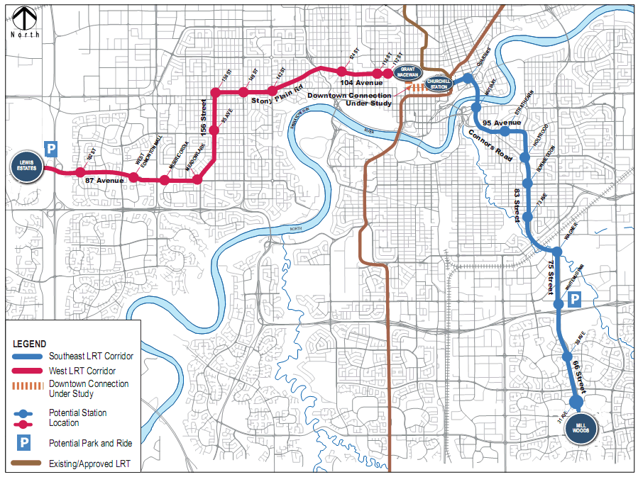
Last month, the City of Edmonton’s Office of the City Auditor completed a review of the Universal Transit Pass (U-Pass) pilot program (PDF). They found that although costs for the program rose, ridership has increased. I took a look at the report, and thought I’d share some of the more interesting facts and figures from it.

For those of you new to U-Pass: it’s a partnership between Edmonton Transit (ETS), St. Albert Transit (StAT), and Strathcona County Transit to provide a universal transit pass to eligible students at the University of Alberta and MacEwan. The current pilot started in the fall of 2007 and will finish up in the fall of 2010.

A total of 84,954 students were eligible in 2008 (counting both the Fall & Winter terms). Here’s the breakdown:

Here’s the revenue that each municipality received in 2008 (the City of Edmonton receives 84%, and the other two each receive 8%):

As the report was created by and for the City of Edmonton, it’s not known what, if any, service changes were made by St. Albert Transit or Strathcona County Transit (unless they too have a report somewhere). ETS made the following changes:

  • 437 service hours were added
  • 3 new routes were added
  • 19 more buses were put into service

Again, we only know the costs for the City of Edmonton. Here are the key figures for 2008:

  • U-Pass Sticker Production costs were $14,500
  • U-Pass Advertising and Promotion costs were $2,928
  • The opportunity cost of the U-Pass program, which is the loss of other ETS fare revenue, was estimated at $10,480,846
  • The cost of providing extra bus service hours was $2,571,221

Add it all up, and you get a total cost of $13,069,495. For the U-Pass program to break even, a fee of $155 per student per term would be required (up from the current $94.50).

In the Edmonton Journal, Councillor Krushell said that ridership nearly doubled from 2006 to 2008, from 7.3 million trips to 13.9 million trips. I’m not exactly sure where she got those numbers, because they aren’t in the report. What is in the report are Campus Passenger Boardings:

As you can see, boardings increased by 21,353 or 12.7% from 2006 to 2008. The report notes that some of this increase may have been caused by factors other than the U-Pass. Other non-financial positives include:

  • An 8% decrease in student parking permits at the University of Alberta since 2006
  • A greater than 8% drop in monthly parking passes at MacEwan for 2007 over 2006

And of course, there has likely been a positive impact on the environment with fewer students driving.

What’s next for the U-Pass?

Although NAIT students initially rejected the program in 2007, a recent survey indicated that a majority would now be interested in joining. The NAIT Students Association hopes to hold a referendum on the issue early next year. The expansion of the LRT to NAIT will no doubt have an impact on interest. If approved, NAIT could join the program for the 2010-2011 school year.

I suspect the program will continue after the current agreement ends, though it is likely that U-Pass fees will rise. Watch for news on a new agreement early next year – the U of A will be holding a student referendum in March to approve new fees, according to The Journal.

Recap: TransitCamp Edmonton

On Saturday, May 30th we held the first ever TransitCamp here in Edmonton. Overall I’d say it was a success, though it didn’t quite turn out the way I had expected! I guess that’s the way it goes with unconferences. We had about 50 people in attendance, and my primary goal of getting a group of interested citizens together with ETS to talk about transit was achieved. Most people I had a chance to talk to after said they enjoyed the event, which was great to hear.

The main issue was that we didn’t have Internet access at the World Trade Centre, despite being promised connectivity when we negotiated the space. We had a few other options (AirCard from Chris, going down to the ETS offices in Scotia Place) but they resulted in confusion more than anything. In the end we decided to cancel the two Skype sessions, which was really unfortunate but allowed us to continue.

During the confusion, however, something really interesting happened. People just started sharing and talking in little groups! It was great to see such conversations taking place, and I suppose the lesson is that they probably wouldn’t have if everything had gone according to plan.

The sessions were all great, I thought. Chris Moore started things off with an interactive discussion about Edmonton Transit IT, examining what we have now, what we’ll have if nothing changes, and what we could have if we consider some possibilities. Next up was Rhonda Toohey, who shared with us the 100 Year LRT Expansion Plan that will go before council on June 2nd. We had two ETS Platinum Bus tours with Dennis Nowicki, and everyone seemed quite impressed with the high tech buses. Brendan Van Alstine led a discussion about TRUE. I shared my presentation on Data for Developers – software developers, not land developers! Councillor Iveson finished the day off talking about “Selling Transit”, using Toronto’s Transit City (which is what Adam Giambrone was scheduled to present) as an example of a successful sell. Throughout the day we had a whiteboard where anyone could write down a question, and we answered most of them during the wrap-up session.

I’ll be working to update the TransitCamp Edmonton site with slides, resources, and more information over the next couple weeks. Be sure to check out Alain’s post on the event, and the iNews880 coverage also. Sharon took a few photos during the day, which you can see here. Eugene posted some photos here, and Grant recorded some video that you can watch here.

Thanks to everyone who came out to TransitCamp, and a special shout-out to the three who came up from Calgary! I hope we’re able to do it again soon (in a venue with Internet) – though maybe in a different format. Let me know if you have any feedback, suggestions, or other ideas!

TransitCamp Edmonton: Data for Developers

I’ve been looking forward to this presentation for a long time! As you may know, I’ve been one of the more vocal citizens asking for an API or data dump from Edmonton Transit. I think only positive things will result from giving everyone access to the data! ETS simply doesn’t have the resources to build interfaces for the iPhone, SMS, etc., so releasing the data would enable other people to build them instead!

Today at TransitCamp Edmonton, I’m pleased to share with you that ETS has become the 2nd transit authority in Canada (and 29th in the world) to release their route and schedule information for free in the GTFS format!

Here are the slides from my presentation:

The ETS GTFS data is about 16 MB compressed and 177 MB uncompressed, so it’s quite a bit of data. If you’re looking for some help getting started, I’d suggest checking out the googletransitdatafeed project and the timetablepublisher project.

We’re also going to be holding a programming competition, as a little extra incentive for you to build something cool and useful with the data. So far we’ve got three prizes: 6 months of free transit for first place, 4 months for second place, and 2 months for third place (to clarify: that’s 6 months for the team, not for each individual on the team). I don’t have all the details yet, but stay tuned. I’ll be posting more information on the TransitCamp site (and here).

I think this is fantastic. Open cities are the future, and this is a big step in the right direction for the City of Edmonton.

Introducing TransitCamp Edmonton!

I’m excited to finally announce TransitCamp Edmonton! We’re still finalizing all of the details, but we have enough nailed down now that we figured it was time to share. Inspired by BarCamp and similar events, TransitCamp is the start of a two-way dialogue about transit in Edmonton, bringing together ETS officials and citizens to discuss a range of topics. Here are the details so far:

WHO: You!
WHAT: Edmonton’s first TransitCamp!
WHERE: Edmonton World Trade Centre (9990 Jasper Avenue)map
WHEN: Saturday, May 30th, 2009 from noon until 4:30pm
WHY: Let’s work together to improve and celebrate Edmonton’s transit system!

To RSVP, send an email to transitcampedmonton@gmail.com.

There are a number of people who have come together to make this happen, including myself, Leanne Brown, City Councillor Don Iveson, Cam Linke, Dan Nielsen, and thankfully, Dennis Nowicki and Bruce Beecher from ETS. This is not an ETS event, but they are definitely going to be participating.

A few other cities have held TransitCamps in the past, including Vancouver and Toronto. I particularly like this line from the Toronto Transit Camp wiki:

Toronto Transit Camp is not a complaints department, it is a solution playground.

That’s the vibe we hope to have at our TransitCamp too.

We’re going with a pseudo-BarCamp-style schedule. That means we’ll have a few sessions pre-planned, but also time slots for anyone who’s interested to present a topic or lead a discussion. We’re still working on the pre-planned sessions, but here’s what we have so far:

  • I’ll be making an announcement related to the ETS data/API
  • Jhenifer Pabillano, TransLink’s uber blogger, has agreed to join us via Skype to chat about community engagement

I also wanted to provide a little background. I was somewhat disappointed to learn that there would not be an ETS Community Conference this year, though I’ll admit it wasn’t the best event in the world. It was very much a one-way event, but it was better than nothing. True, there was the ETS Community Fair, but that didn’t really provide an opportunity to talk with ETS on a serious, “let’s get stuff done” kind of level. It was more of a fun event, with face-painting, etc.

Don Iveson and his team have been interested in the idea of a TransitCamp for some time. Cam and I were talking with them about it a few months ago, and I volunteered to sort of take the lead on the project. I’ve been working with Leanne since then to make this happen. In the last few weeks, everything started to fall into place!

As you may have seen, quite a few people started using the #yegtransit hashtag on Twitter over the weekend, so let’s keep using that. For now, you can see related tweets here.

There’s lots of cool stuff still to come, so stay tuned. I hope you’ll join us on May 30th!

Edmonton’s LRT now extends to South Campus

This morning I went down to Health Sciences/Jubilee LRT Station for the grand opening of Edmonton’s two newest LRT stations – McKernan/Belgravia (114th Street and 76th Avenue) and South Campus (116th Street and 65th Avenue). Construction of the 2.3km extension south from Health Sciences began in 2005. Regular transit service begins tomorrow.

South Campus LRT Grand OpeningSouth Campus LRT Grand Opening

I received the media advisory about the event earlier this week, and had to read it twice:

To ride the ceremonial train, media MUST park in the designated parking lot at South Campus. From there, media and dignitaries will board an ETS shuttle at 9:15 a.m. which will travel to the Health Sciences Station where the LRT will depart as part of the official opening ceremonies.

This is a transit event, yet the media must drive and park? They could have at least encouraged everyone to take the bus or train! I understand the media sometimes carry a lot of equipment, but seriously. Sharon and I took the train to Health Sciences and met the group there. I was happy to see that ETS seemed to consider bloggers and other citizen journalists part of the media, though I suppose it would have been logistically impossible to turn anyone away (the train was packed).

In any case, we got to ride the first public LRT train on the new south extension. We stopped for a short ceremony at McKernan/Belgravia, where a group of residents had gathered to welcome the arrival of the first train. The total trip from Health Sciences was about two minutes:

Next of course, was the trip to South Campus. I sat across from Mayor Mandel, who happily chatted with everyone around him. At one point he said of the extension: “This is great, but it’s history now. We need to keep going.” He later reiterated this in his official remarks. Fortunately, construction of the track to Century Park (formerly Heritage) is well underway (and should open in April 2010). The trip from McKernan/Belgravia to South Campus was also about two minutes:

The South Campus LRT station also had a large group of people to welcome the train, and played host to the ETS Community Fair after the opening ceremony. Mayor Mandel, Minister of Labour Rona Ambrose, Minister of Aboriginal Relations Gene Zwozdesky, and University of Alberta VP Facilities and Operations Don Hickey all said a few words and participated in the unveiling of the commemorative plaque.

South Campus LRT Grand Opening

I was struck by how empty the area looks – there’s not much around the station right now. It will become a major transit hub however, as ETS is re-routing bus service to feed into the LRT system. You can read about all the transit service changes here.

South Campus LRT Grand OpeningETS Community Fair

The opening of these two stations is a great thing for Edmonton. I look forward to many more LRT station launches in the hopefully not-too-distant future. You can see more photos of the event here. The official news release is here.

Edmonton Transit (ETS) – The Every Day Way

As you may have noticed, Edmonton Transit (ETS) has launched a new marketing campaign in conjunction with the grand opening of the McKernan/Belgravia and South Campus LRT Stations. I’m not sure which agency created the concept (or if it was done in-house), but I love it!

The Every Day WayThe campaign uses simple, bold wording and color schemes to convey a simple message: ETS is the every day way.

This is the right message for ETS. They need to get across the idea that you can use public transit as part of your daily routine. That transit can fit into your life in a positive way!

So far I’ve seen three:

  • The every day way to go green with a new routine
  • The every day way to save $5500 a year
  • The every day way to South Campus

Here are some others that could work:

  • The every day way to save money on parking and gas
  • The every day way to achieve a less-stressful commute
  • The every day way to reach your destination safely
  • The every day way to the Edmonton Eskimos

A second stage of the campaign could have real people in the ads, to try to eliminate any negative perceptions attached to riding the bus. I’m thinking “The every day way for Don Iveson” with a photo of him, that kind of thing. They don’t all have to be local celebrities, but a few wouldn’t hurt!

So far I’ve seen the ads in fluorescent green and pink on bus shelters, benches, and billboards. I’d really love to see the campaign expanded to other mediums also. How about radio spots? Internet ads? It’s a simple message that can be shared very easily.

What do you think – does the new campaign hit the mark?

Social Media: What Edmonton Transit (ETS) could learn from TransLink

I think the South Coast BC Transportation Authority, or TransLink, is one of the most web-savvy transit organizations in Canada. Through blog posts, videos, meetups, and more, TransLink is doing a great job of fostering a community of people interested in transit. I think Edmonton Transit (ETS) could learn a lot from them!

The Buzzer blog

The Buzzer is a free publication found on all TransLink vehicles (our equivalent is In Transit) and The Buzzer blog is its companion. The blog is described as a “frank, fun, and ongoing conversation about TransLink and its work.” Every time I read it, I find myself wishing that ETS had something similar! Here’s what I love about the blog:

  • It is updated regularly – almost a post per day!
  • They have comments enabled – and they participate in them!
  • They post about a variety of topics, not just announcements and service updates
  • There are clearly defined Participation Guidelines

Most importantly, the blog is written with a human voice. It’s interesting and easy to read.

What ETS could learn: The easiest, most effective way to get involved is to start a friendly, regularly updated blog. It forms the foundation of TransLink’s social media efforts, and could perform the same role for ETS. This should be priority #1!

TransLinkInfo on YouTube

Video is time-consuming both to produce and to consume, so while it shouldn’t be the primary form of communication there are times when video is handy. TransLink gets this. They primarily post short updates and announcements on their YouTube channel. Videos range from about 30 seconds to 5 minutes. I think it could be a good vehicle for “behind-the-scenes” kinds of stories as well.

What ETS could learn: Pick the right tool for the job. There’s more to the web than just text, so venture into other forms of media too!

TransLink on Twitter

There are a few TransLink accounts on Twitter: @thebuzzer, @KenHardie, @2010Transit, and @TransLink. I think the 2010 account will get more interesting as the Olympics near, and The Buzzer account could probably be used for more than just broadcasting, but they are on Twitter and are evaluating how to use it better (they recently polled the community to see if they wanted Twitter service alerts). It’s pretty cool that Ken Hardie, Director of Communications at TransLink, is an active user.

What ETS could learn: Twitter is growing incredibly quickly and is becoming an increasingly important platform for news and connections. TransLink is guessing (I think correctly) that Twitter will be a key communications tool for the 2010 Olympics, and they’re getting prepared now. ETS would be wise to make use of Twitter on a regular basis, and especially during Edmonton’s major events.

I Love Transit Week & The Buzzer Meetup

TransLink celebrated I Love Transit Week on its blog from February 23rd to 27th. I like their introduction to the event:

Why? Because while there are things we don’t like about transit, I know there are many things that we do like about the system. And there just hasn’t been an official opportunity to celebrate what we like – until now!

That could definitely apply to something similar here in Edmonton. We always hear people complain, but there are lots of things to like as well. TransLink did a good job of keeping the blog updated with I Love Transit Week content.

The other cool thing they did that week, was the meetup. They hosted the gathering at a local cafe, and brought transit-related swag to give away. Face-to-face conversations are always best, so the meetup was a great (and obvious) idea.

What ETS could learn: The annual Community Conference is a formal, one-way conversation – ETS speaking to a select few. Meetups are more informal, and are two-way. They allow the community to put human faces to the organization. Plus they can be a ton of fun!

Final Thoughts

I don’t mean to suggest that TransLink is perfect, because they’re not. And to be fair, ETS acknowledges that it has a lot of work to do in the area of community engagement. Like many other organizations they are new to social media, and are going to have to learn quickly.

Conversations about the state of transit in Edmonton are happening, but ETS isn’t yet participating. The sooner they get involved, the better off they’ll be. Fortunately for ETS, they don’t have to start from scratch. Others like TransLink are already leading the way!

Edmonton Transit (ETS) officially launches Google Transit trip planning

As you may have heard yesterday, Edmonton Transit (ETS) now officially supports Google Transit for trip planning. What that means is that you can enter an address in Google Maps and get directions using public transit to another address. You can look up trip plans from any device that supports Google Maps, including the BlackBerry and iPhone. This has actually been possible since late October, as I mentioned in a previous post.

Edmonton is the 8th Canadian city to support Google Transit. Councillor Don Iveson demonstrated the service today at City Hall. You can read the press release here, and you can check out the official ETS page here.

ETS Google Transit Press Event

You can see more photos and video from today’s event here.

So what’s new?

First and foremost, the data is up-to-date and accurate (more on this below). You generally don’t have to worry about relying on the data in Google Transit. Secondly, Google Transit now understands ETS landmarks. This means you can type your home address as a starting point and “Millgate Transit Centre” as the destination, and Google will understand what you mean. These are the two primary reasons that ETS didn’t officially launch this back in the fall.

How does it work?

ETS has an agreement with Google to provide them with up-to-date data once a week (this time period can be different for each transit agency). If there’s a change in the accuracy of the data, ETS must provide Google with an update. This means there may be a small window of time during which ETS has more accurate information than Google, but in practice that’ll only happen for emergencies as most changes are planned and announced in advance.

The data is transferred in a format called the Google Transit Feed Specification (GTFS). It’s up to ETS to ensure the GTFS data they provide is valid. Now that the “preview” period is over, Google automatically fetches the most recent data from ETS servers and applies it to Google Maps.

Why is this service important?

The Google Transit service offers a number of benefits. It’s really easy to use – just enter a start and end address and click get directions. I think it’s great for attracting more ridership to ETS as well. Young people are already familiar with Google Maps, and the thousands of individuals walking around with smartphones now have trip planning with them at all times. Visitors to our city are another group that will benefit, as they’re likely already familiar with Google Maps and no longer have to figure out the ETS trip planner.

What’s next?

Marketing will be the biggest thing initially. This service is only useful if people know about it! Edmonton was just listed on the Google Transit site, and information about Google Transit was just added to the ETS site this morning. Presumably introductions to the service will be added to all of the ETS information and promotional materials as well.

Though ETS is working on improvements to its own trip planner (which originally launched back on June 21, 2004), they fully expect usage to decline as people switch to Google Transit. Unfortunately, Google doesn’t provide transit agencies with statistics of any kind, so ETS won’t know exactly how many people are using the new service. Both services will co-exist.

Can we get the data now please?

I hope access to the GTFS data will be made available soon. Now that ETS has sorted out the process for publishing the data for Google, hopefully it’ll be simpler to come up with a process for getting the data to the rest of us too. Many other municipalities already publish their GTFS feeds for public consumption. There are lots of resources available for developers too, such as the GoogleTransitDataFeed open source project. Access to the data is the first step toward building an API for Edmonton Transit (ETS).

In the meantime, trip planning in Edmonton is now faster and easier! Click here to get started.