Edmonton’s High Level Bridge has lights…now what?

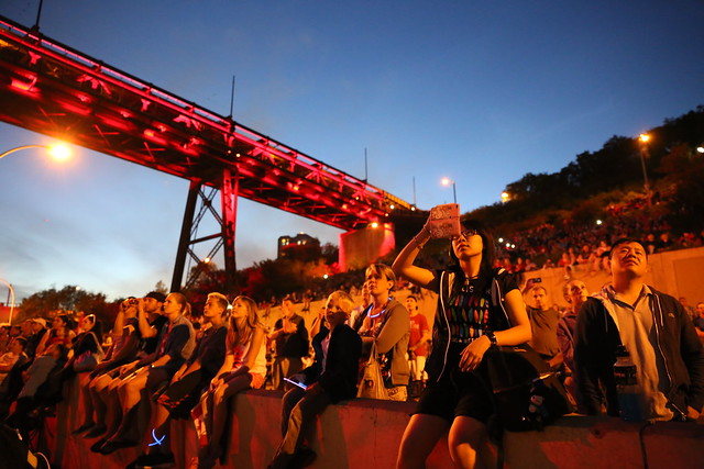
In case you missed it, here’s my recap of the light up that took place on Canada Day. Now that the lights are turned on, I had some questions about them, and I heard some common questions from others too. So I reached out to the Light the Bridge team for answers. Here’s what I found out!

High Level Bridge

When will the bridge be lit?

Every single night, 365 days a year. You can always go check out the lights at night!

What time do the lights come on and off?

It varies depending on the time of year. In the summer, they’ll come on later at night and turn off sooner. In the winter the lights will come on earlier in the evening, and may also be on in the early morning to brighten the commute. The City of Edmonton will control this, and the exact schedule is still being determined.

How are the colors/animations decided?

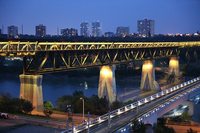
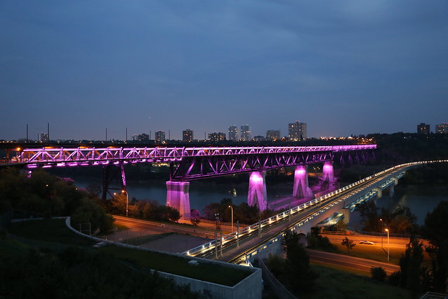
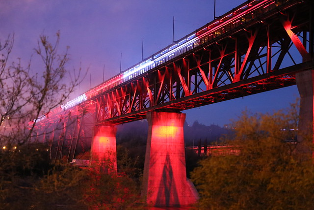
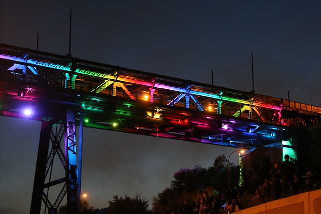
Right now the bridge lights seem to alternate from one solid color to another – green to blue to yellow to red, etc. For special events, the bridge may be lit differently (for instance, green and gold for an Eskimos game). The City of Edmonton’s Civic Events department has final say over the light colors and animations. In the future, individuals and organizations will be able to request special colors or animations – processes for that are being developed now.

Can the lights be used for advertising?

No. Not only was this a core principle established early on in the project, but the trellis structure of the bridge means there are no flat surfaces upon which words or ads could be placed. The bridge is not meant to be a billboard.

How can I find out what the colors on a given night are for?

I love the Tower Lights site for the Empire State Building in New York. You can always go and see what the colors meant for any given day. I understand the City will be creating a similar online tool so that you can see why the bridge is lit a certain way.

Where are the lights controlled from?

The lights are controlled from the City of Edmonton’s Network Operations Centre.

Who maintains the lights and pays for that maintenance?

The City of Edmonton will maintain the LED lights, just as they maintain all other lights on the bridge.

How much does it cost to light the bridge?

The annual electrical costs of running the new LED lights on the bridge are about the same annual costs as running 3-4 houses (assuming the lights are on an average of 7 hours every day).

Will the bridge contribute to light pollution?

Lights on the bridge are pointed downwards, and using LED lights allows the lights to be projected at specific points on the bridge, which minimizes the impact of light pollution. There is little to no light pollution.

I bought one or more bulbs, how can I find their location?

There’s a tool up on the Light the Bridge site now that lets you search for the location of your bulb(s) by last name, email address, or dedication. I bought two: one is light #3-1-6 (East Facing) and the other is light #4-4-56 (East Facing). You can also browse the lights manually and look at all the names and dedications. It’s a pretty neat collection of stories!

High Level Bridge

We’ve come a long way from the waterfall. Go check out the lights!

Recap: High Level Bridge light up on Canada Day

Thousands of Edmontonians lined the river valley on Canada Day to catch a glimpse of not only fireworks, but also the official light up of the High Level Bridge. The project was greenlit back in March when the necessary $2.5 million to purchase and install 50,000 LED bulbs on the bridge was successfully raised. Over the last month the lights were installed and tested in preparation for Canada Day.

Canada Day 2014

There were people everywhere last night – every path, ledge, and patch of grass was claimed by someone eager to see the lights and fireworks! Some folks brought chairs, others had blankets. There were lots of tripods and other camera setups.

Canada Day 2014

As the unveiling approached, singing of “O Canada” and chants of “CAN-A-DA!” could be heard all along River Valley Road. Finally, about five minutes past ten, the lights came on, and a couple minutes later, the fireworks began!

Canada Day 2014

Here’s the official video from Light the Bridge, with music performed by the Edmonton Symphony Orchestra. The music was broadcast live on CKUA.

There was a lot of cheering, oohing, and ahhing as the lights came on. For about two minutes they danced across the bridge, giving us a glimpse of what can be done in the future.

Canada Day 2014

I was cautiously optimistic about how the lights would look, especially as I don’t feel the lights on the ATB Tower downtown look that great. Color me impressed though, they look great! Mayor Iveson, Dave Mowat, and others have been talking about how this could be our postcard photo, and now having seen the lights, I can see what they mean.

Canada Day 2014

It’ll be interesting to see how they light the bridge in the future. We’ve heard that it could be green and gold for the Eskimos, copper and blue for the Oilers, and evidently, rainbow colored for Pride!

Canada Day 2014

Congratulations to Dave Mowat and everyone at ATB, David Stevens and the folks at EPCOR, Tammy Pidner and the team at EEDC, and everyone else who worked hard to make this project a reality!

If you want to buy a bulb, you have until July 11 to do so. If you already bought one, head over to the website to find the location of yours. You can follow Light the Bridge on Twitter for updates.

Adventure in Edmonton: Fort Edmonton Footbridge & Wolf Willow Ravine

Last year the City of Edmonton completed work on the new Fort Edmonton Footbridge. In addition to the bridge, the $28.2 million project included 2.5 km of access trails and stairs and a secondary bridge crossing at Wolf Willow Ravine. The design was selected to achieve the objective of “better design in a world class city.” Here’s what it looks like (from the east side looking west):

Fort Edmonton Footbridge

David Staples wrote about the new bridge in August, and both Sharon and I made a note of the article at the time. He wrote:

“The most beautiful structure you’ve not yet seen in Edmonton, the new Fort Edmonton Footbridge, now spans the North Saskatchewan River. It is a testament to the city’s new vision to invest in attractive infrastructure, not just the same old ugly.”

We had to see it for ourselves! A number of other recent “sightings” only increased our desire to check it out (a friend’s wedding photos and one of EIFF’s 24/ONE videos were shot there). Last weekend we finally made time to go. I fired up Google, and quickly arrived at this page on the City’s website. I was looking for an address or directions or something, but all that page offers is the following:

The footbridge crosses the North Saskatchewan River upstream of Fort Edmonton Park and affords a connection between the new multi-use Trans Canada Trail around Fort Edmonton Park and new park land purchased on the west side of the river (Centennial Lands) in 2007.

There’s also a link to this PDF map which shows the proposed design, not the final result. And because it’s a satellite image without labels, figuring out which route to take to get to the bridge is anything but simple. Thankfully, Google does show the crossing:

We still weren’t entirely sure how to get there, but at least that map narrowed it down. It looked closer to park at the end of Whitemud Road (yes, ignoring the no parking signs) and walk rather than driving into Wolf Willow, so that’s what we did. There’s probably a better way to get there. Oh how we need trail maps data in the data catalogue!

Fort Edmonton Footbridge

The drive/walk to the bridge was interesting, as the neighbourhood is full of mansions! The trail from Whitemud Road to the bridge is situated in between two very large houses. Must be nice to have the bridge in your backyard!

Fort Edmonton Footbridge

The bridge itself is beautiful. As you can see it is highest in the middle, so the incline upward from each shore combined with the cables gives it a nice effect in photos.

Fort Edmonton Footbridge

I’m also a fan of the asymmetrical layout, with one of these lookout points on the northwest side of the bridge and another on the southeast.

Fort Edmonton Footbridge

The trail to Wolf Willow Ravine on the west side of the bridge is very pretty. There were a bunch of photographers using the trail when we visited, including one taking what appeared to be engagement photos for a young couple.

Wolf Willow Ravine

I had no idea Wolf Willow Ravine even existed until our trip. It was a crisp and cool when we were there, and so quiet. Sharon remarked that she felt like we were in Banff – it was certainly a different side of Edmonton than we’re used to seeing!

Fort Edmonton Footbridge

You can see the rest of my photos here. Go visit the Fort Edmonton Footbridge when you get a chance. It’s a bit of a trek to get there, but it’s worth it!

Capital City Clean Up – 15 to Clean Challenge!

Now that the snow has melted, litter is once again visible on our streets and sidewalks. That means it’s time for a big push by Capital City Clean Up (CCCU), the City of Edmonton’s year-round litter and graffiti management program.

On Wednesday, Mayor Mandel kicked off the latest CCCU initiative, called the 15 to Clean Challenge:

“The responsibility for keeping our city clean is shared by all of us. If we all took 15 minutes to clean up litter or wipe out graffiti, imagine how much of a difference we could make together,” said Mayor Stephen Mandel. “Edmontonians take pride in their city and show it by participating in events like this.”

Participating in the challenge is easy. Just take 15 minutes to pick up some litter or call 311 to report graffiti. Challenge your friends and co-workers and go as a group! When you’re done, log your clean up activities online (you have until May 16 to do so).


Photos by Raffaella Loro (see more here)

I took part in a clean up group last year and had lots of fun! Last year was a great year for CCCU. Here is 2009 by-the-numbers:

  • 4758 – Adopt-a-Block Team Members recruited
  • 11588 – bags of Adopt-a-Block trash collected
  • 246 – litter tickets issued
  • 11160 – hours volunteered collecting litter
  • 13158 – square meters of graffiti painted/cleaned (141628 square feet)
  • 546 – graffiti wipeout volunteers
  • 266 – graffiti wipeout kits issued
  • 3276 – Graffiti Clean Up volunteer hours
  • 98 – graffiti tickets issued
  • 27 – CCCU program partners
  • 6458 – bags of trash collected during River Valley Clean Up
  • 7319 – volunteer hours for River Valley Clean Up

River Valley Clean Up kicks off next week (on ShareEdmonton) – you can learn more here. If you’d like to Adopt-a-Block, you can do so here.

Fifteen minutes is all it takes! Get out and help to clean up Edmonton!

Why I’m excited for the Southeast LRT

Now that I’ve had a chance to think and talk to a few people about yesterday’s LRT route announcements, there is one aspect in particular of the Southeast LRT route that I am quite excited about.

Can this:

Pic of the Day #965 by Kenneth Hynek

Go with these?

Fall Photowalk in EdmontonMuttart - May 12 024 - by A.N.U.J

I think the answer is a big yes (minus the high-floor, underground, elaborate stations…low-floor FTW).

If you look closely at the recommended route for the Southeast LRT corridor, you’ll notice that it goes from downtown through Louise McKinney Riverfront Park and across the river to the Muttart Conservatory (where there should be a stop).

Did you catch that? The LRT will go through the crown jewel of Edmonton, the river valley!

A low-floor, urban style LRT route from downtown through the river valley opens the door to all kinds of possibilities. Most obviously, it makes the river valley accessible to all – no more talk of building an incredibly expensive funicular. More significantly, it creates the potential for some development along the river valley. Think riverfront restaurants, pubs, and other attractions. Don’t get me wrong, I don’t want to turn our river valley into an outdoor West Edmonton Mall or anything like that, but I do think that we often fail to make the most of what is perhaps our best asset. I think an LRT stop at the Muttart Conservatory could spur a number of interesting ideas and concepts.

Now to be clear, this isn’t guaranteed to happen. They could still switch the stations or even potentially the route. And I don’t know how they plan to get from downtown down to the river. There are a lot of unknowns. Still, I think the potential for this is incredible. That’s why I’m excited about the Southeast LRT route, and why I think you should be too!

Photo credits: A.N.U.J, mastermaq, Kenneth Hynek