First Look at Edmonton’s South LRT Extension (Southgate & Century Park)

On Saturday, April 24, the two newest LRT stations in Edmonton’s network are officially opening to the public, and ETS is hosting a Community Fair to celebrate (on ShareEdmonton). Yesterday, the local media got a sneak peek at the new Southgate and Century Park stations, both of which have been under construction since the Summer of 2007.

South LRT ExtensionSouth LRT Extension

The total budget for the South LRT Extension from Health Sciences station to Century Park was $690 million, the vast majority of which ($573 million) came from tax supported debt (to be repaid from the New Deal for Cities & Communities). Construction included two new tunnels: one beneath Belgravia road and one beneath the southbound lands of 111th Street. There are also two new bridges: a one-way bridge over Belgravia Road (connects South Campus to Fox Drive) and one across Whitemud Drive. A total of 26 new light rail vehicles were added to help service the extension.

The total length of the South LRT Extension is 7.361 km:

  • Health Sciences to McKernan/Belgravia: 0.9 km (roughly 1 minute, 56 seconds)
  • McKernan/Belgravia to South Campus: 1.375 km (roughly 2 minutes, 24 seconds)
  • South Campus to Southgate: 2.032 km (roughly 3 minutes, 20 seconds)
  • Southgate to Century Park: 3.324 km (roughly 3 minutes, 46 seconds)

The McKernan/Belgravia and South Campus stations opened a year ago, and at the time I complained that the media advisory encouraged driving and parking. I’m happy to report that the media advisory for yesterday’s sneak peek said this:

Please note that there is no public parking available at South Campus Station. Members of the media are urged to use LRT to travel to the event.

Much better – I hope future advisories look the same!

We boarded the train at South Campus, and headed for Southgate station (located on 111th Street between 51st Avenue and Whitemud Drive):

For another view, here’s Southgate back to South Campus. Of the two new stations, I think Southgate is my favorite. It mirrors the recent renovations done to Southgate Shopping Centre very well, so it looks like it belongs. The artwork in the station is called “Immense Mode” and was created by Dawn Detarando and Brian McArthur. We learned about all of the new safety features (including the secure washrooms) and got to wander around. Here are a few photos of the new station:

South LRT ExtensionSouth LRT Extension

South LRT ExtensionSouth LRT Extension

Next up – Century Park (located on 111th Street just north of 23rd Avenue). Unfortunately the batteries in my flip died on the way there, so I don’t have video of Southgate to Century Park. I have the return trip though:

As it is the end of the line (for a while anyway) Century Park will probably be the busiest of the new stations, housing an 1100-stall temporary Park & Ride lot, in addition to 130 existing parking stalls. When the bus routes are changed later this month to feed into the new LRT extension, Century Park will receive the bulk of the traffic. The artwork in the station is called “Continuum” and was created by Cezary and Danielle Gajeweski. Here are a few photos of the new station:

South LRT ExtensionSouth LRT Extension

South LRT ExtensionSouth LRT Extension

If you’d like to check out the new stations for yourself, don’t miss the Community Fair on the 24th. It’ll also be a great opportunity to learn more about the changes to bus routes.

What’s next? Well in addition to needing funds to expand the LRT in other directions, the City is already planning for the next south extension to Ellerslie Road. The preliminary design was approved by City Council in July 2008. You can learn more about the future extension here. The currrent LRT network was built to accommodate four-car trains, but work is underway to upgrade capacity to five-cars. The McKernan/Belgravia and Health Sciences stations are being upgraded now, work which is expected to be complete in October. South Campus, Southgate, and Century Park already support five-car trains.

In just a single year, we’ve had four new LRT stations open in Edmonton. Let’s keep it up! You can see the rest of my photos from the preview here.

Edmonton Transit in 2009

I think 2009 was a very interesting year for transit in Edmonton! There were a number of big successes, such as the launch of trip planning with Google Transit, new LRT cars, the opening of the South Campus LRT Extension, experiments with dedicated bus lanes and smart cards, the release of data for developers, lots of support for transit to the Edmonton International Airport, completion of major construction on the South LRT extension, and of course, the approval of the NAIT, West, and Southeast LRT lines. There was also some sad news, such as the violence against bus drivers and other security issues. And finally, some transit news from 2009 is either positive or negative depending on how you look at it, such as the end of trolley buses.

TransitCamp EdmontonSouth Campus LRT Grand OpeningSouth Campus LRT Grand OpeningMack & DonETS PlatinumMy Bus StopWest & Southeast LRT Announcement

Here are some of the transit-related headlines from 2009:

Also: you can see the monthly In Transit newsletters here.

Some data points for 2009:

  • The 15th annual Stuff A Bus campaign collected 31,000 kg of non perishable food items, and $17,000 in cash donations.
  • On February 1, 2009, the price of an adult monthly pass rose $7.75 to $74.25.
  • In its first six months of operation, 311 fielded 116,437 calls related to trip planning, 63,980 calls related to bus information, and 6,037 calls related to transit fares. Transit was the most commonly requested service.
  • ETS Statistics and ETS Statistics for 2009 (will be updated).

TransitCamp Edmonton Competition

At the TransitCamp Edmonton event on May 30th, it was announced that ETS was releasing route & schedule information in the Google Transit Feed Specification (GTFS) format for everyone to use. We decided to hold a small competition, to spur interest in developing applications that made use of the data! The competition closed November 30th, and I’m happy to finally share our two winners:

  1. MyStops by Grayscale Apps
  2. ETS Trip Planner by Waclaw Lany

MyStops, as you probably know, is a very popular iPhone application that gives you quick access to the schedule information for your favorite bus stops. Waclaw’s trip planner combines the stop number functionality of the official ETS Trip Planner with Google Maps routing.

Our judges, Councillor Don Iveson and Edmonton CIO Chris Moore, evaluated the submissions using three criteria:

  • Usefulness to residents
  • Visual appeal and usability
  • Inventiveness and originality

Congratulations to Andrew, Sinan, Sari, and Waclaw!

2010

This should be another big year for transit in Edmonton. The last of the old GMC vehicles were retired in 2009, which means that ETS is now running a 100% accessible fleet. The South LRT extension is scheduled to open in April, and construction on the North LRT extension has begun. The U-Pass pilot ends this year, so a new deal will be negotiated, and NAIT students might get to join. And hopefully at some point the trolley wires will be completely removed! I can’t wait to see what else 2010 has in store for us.

Don’t forget: the Donate-a-Ride campaign is on until January 31!

Keep up-to-date on the latest transit news and announcements on Twitter using the #yegtransit hashtag!

Did I miss anything? Let me know in the comments or via email.

Leveraging Technical Expertise Locally (LTEL) Application Deadline: December 15

Just a reminder that if you’re planning to participate in the Leveraging Technical Expertise Locally (LTEL) initiative, you have until next Tuesday to declare your interest! If this is the first you’ve heard of LTEL, check out my recap of last month’s open house. Expressing interest is easy – just fill out this online form. You’ll need to provide your personal and business contact details, as well as:

  • A description of your solution in 100 words or less
  • An overview of your solution in 200 words or less (no I don’t know how the description and overview are different)
  • The top 10 features of your solution
  • The technical specifications of your solution
  • Direct & indirect benefits and costs of your solution
  • An explanation of how your solution will address the technical and operational needs of the customer and end-user
  • A preliminary timeline for your solution

Interestingly, there’s also room for three team member profiles, and comments on product differentiation, commercialization potential, and financial considerations. So if you have sales projections or plans to look for investment, you can mention that up front.

The website has a number of useful documents that might be of interest, including a scan of the current Lost & Found form and tag (pictured above). You can also download the City’s IT standards, which have been clarified:

The City does not wish to dictate the technologies proposed by the applicant, however, the solution must run in the City’s technical environment, as City staff are expected to use the application on a daily basis. In addition, the City is open to considering proposals that include hosting of the proposed application.

Emphasis mine – that’s great to hear!

If you’re chosen to continue, the next step in the process is to present your solution to the selection panel on January 28, 2010. Your solution doesn’t need to be complete by that date – mockups, prototypes, or whatever you’re comfortable presenting is fine. The selection will be announced on February 3, 2010.

For more information, check out the LTEL site. If you have questions or other concerns, email LTEL@edmonton.ca. Have a great idea for a new Lost & Found system? Apply now!

Edmonton’s 311: six month status report

As you’ve probably heard by now, the City’s 311 service is not performing as well as expected. The Sun first reported the story last week, and the Journal followed up with an article yesterday. They key point mentioned in both is that wait times to connect to an operator are far longer than originally anticipated. As a result, an interactive voice response system is being considered for next year. I can’t imagine that will make callers any happier, even if it does make their calls slightly faster.

I personally think they should put more resources into 311 online. How many citizens even realize that they get online access to a lot of the information and services that 311 provides? The best way to reduce call times is to increase self-service options and quality so that citizens can bypass the phone altogether.

Fortunately, there are new self-service features being developed for release in October. The City will still need to communicate their existence effectively, however.

Background

The CRTC approved the use of the 311 phone number for municipal services back in November 2004, and Calgary became the first city to launch 311 on May 8, 2005. Here in Edmonton, City Council approved the service at its May 9, 2006 meeting. Edmonton became the first city in North America to use SAP’s CRM application to deliver 311.

The 311 service officially launched on December 16, 2008. Implementation was approved at a cost not to exceed $10 million (and it is on track to come in about $1.5 million under budget). Half of that amount came from an internal loan, which is to be repaid from operating savings (the other half came from a special dividend in 2005).

Six Months In

The report that went to the Executive Committee this week isn’t incredibly long at 7 pages, but it does have lots of information. Here are some graphics to help make it easier to understand the first six months of 311 operation in Edmonton.

Call lengths are one of the reasons everyone is complaining:

Wait times to get through to an operator are another concern:

The 311 system was supposed to help the City capture the estimated 160,000 missed calls each year, but so far it is on track to make things much worse:

The report contains information about the top ten services:

Transit inquiries make up a significant portion of all 311 calls, followed by Community Services inquiries. There’s a clear opportunity for transit to do more to reduce the number of calls going through 311. I find it odd that trip planning is such a common request actually, given that there’s a separate number for that (BusLink) not to mention the online trip planner and Google Maps.

Here’s the breakdown by department:

There are a few more graphs (without data values unfortunately) in the report, so take a look at those too. They show that the number of calls answered within 25 seconds is on the rise, and that the time it takes to get through to someone is declining.

Does this report suggest that 311 is “a disaster”? I don’t think so. All it shows is that there is work to do, and it sounds like the 311 team is on the case. Hopefully the departments they serve are as well.

Why I’m excited for the Southeast LRT

Now that I’ve had a chance to think and talk to a few people about yesterday’s LRT route announcements, there is one aspect in particular of the Southeast LRT route that I am quite excited about.

Can this:

Pic of the Day #965 by Kenneth Hynek

Go with these?

Fall Photowalk in EdmontonMuttart - May 12 024 - by A.N.U.J

I think the answer is a big yes (minus the high-floor, underground, elaborate stations…low-floor FTW).

If you look closely at the recommended route for the Southeast LRT corridor, you’ll notice that it goes from downtown through Louise McKinney Riverfront Park and across the river to the Muttart Conservatory (where there should be a stop).

Did you catch that? The LRT will go through the crown jewel of Edmonton, the river valley!

A low-floor, urban style LRT route from downtown through the river valley opens the door to all kinds of possibilities. Most obviously, it makes the river valley accessible to all – no more talk of building an incredibly expensive funicular. More significantly, it creates the potential for some development along the river valley. Think riverfront restaurants, pubs, and other attractions. Don’t get me wrong, I don’t want to turn our river valley into an outdoor West Edmonton Mall or anything like that, but I do think that we often fail to make the most of what is perhaps our best asset. I think an LRT stop at the Muttart Conservatory could spur a number of interesting ideas and concepts.

Now to be clear, this isn’t guaranteed to happen. They could still switch the stations or even potentially the route. And I don’t know how they plan to get from downtown down to the river. There are a lot of unknowns. Still, I think the potential for this is incredible. That’s why I’m excited about the Southeast LRT route, and why I think you should be too!

Photo credits: A.N.U.J, mastermaq, Kenneth Hynek

West & Southeast Edmonton LRT Route Recommendations

This afternoon Edmonton Transit announced its recommended routes for West and Southeast LRT lines. The routes “work towards the Transportation Master Plan’s vision to expand LRT service to all sectors of the City of Edmonton by 2040.” Back in June, City Council approved the LRT Network Plan, which identifies how the LRT system will be expanded. These two routes are part of that plan.

Here’s what the recommended routes look like (click for a larger image):

There was a lot of information shared during today’s briefing, which I did my best to live-tweet. Here are some of the highlights:

  • This is not the LRT you’re used to – it’s low floor technology with smaller, urban style stations.
  • Initially, there are seven stations planned for the West LRT route and six for the Southeast LRT route.
  • The two routes are actually part of a single line, which means you’ll be able to travel from Mill Woods to Lewis Estates without any transfers.
  • Travel time from either end to downtown will be 20-25 minutes. Both speed and carrying capacity is expected to be the same as the current LRT line.
  • The estimated cost for each route is between $900 million and $1.2 billion.
  • Short-to-medium term ridership for each line is expected to be 45,000 riders per day by 2040.
  • Though bus routes will almost certainly be eliminated, service hours will likely remain the same and will simply shift elsewhere (so in effect, the LRT is making the bus system more efficient).
  • The downtown connection still needs to be considered.

The routes were evaluated based on a new set of decision-making criteria established in December 2008 for LRT route planning. Initial screening looks at feasibility, community, and environment. The next stage is the specific evaluation criteria, with weights in brackets:

  • Land-use/Promoting Compact Urban Form (4)
  • Movement of People/Goods (3)
  • Feasibility/Construction (2)
  • Parks, River Valley and Ravine System (2)
  • Social Environment (2)
  • Natural Environment (2)

Southeast LRT

Recommended Route
Route Options

The Southeast LRT corridor travels north from Mill Woods Town Centre on 66 Street, continuing north on 75 Street. It then uses Wagner Road to extend either over or under the CP Rail line to 83 Street. From there, it proceeds along 83/85 Street north to 95 Avenue, then along 95 Avenue to Connors Road with the route crossing the North Saskatchewan River, either replacing the Cloverdale footbridge or adjacent to it, and east into downtown to connect to the proposed Quarters development, providing a surface (street level) connection to Churchill LRT station, ultimately connecting to Grant MacEwan College.

Major potential stations: Muttart Conservatory, Bonnie Doon Mall, Grey Nuns Hospital, Mill Woods Town Centre

Key benefit: Direct link to downtown, minimizes traffic impacts to Connors Road.
Key weakness: Neighbourhood disruption.

West LRT

Recommended Route
Route Options

The West LRT corridor goes from Lewis Estates east along 87 Avenue, then north on 156 Street. It connects to downtown via Stony Plain Road and 104 Avenue, providing a surface (street level) connection to Grant MacEwan College.

Major potential stations: MacEwan, Oliver Square, Jasper Gates, MacEwan Arts Campus, Jasper Place, Meadowlark Shopping Centre, Misericordia Hospital, West Edmonton Mall

Key benefit: Direct connection to downtown, opportunity to transform Stony Plain Road into a transit corridor for west neighbourhoods.
Key weakness: Impact on established neighbourhoods.

Discussion & Analysis

At this point, I’m simply happy to see this moving ahead. The South LRT expansion has been going well, and it’s important to keep momentum and interest. The West LRT route has definitely been the more controversial of the two, and I don’t see that changing (which likely means that the Southeast LRT route will get built first).

I talked to Councillor Kim Krushell this afternoon to get her thoughts on the recommended routes. While she too was happy to see progress, she had reservations about the West route, telling me that she didn’t necessarily agree with the weighting of the evaluation criteria. “Some estimates put the number of people working at the U of A at 50,000 and the number working downtown at 60,000. The recommended route bypasses a major employment centre.” While she’s “not against the Stony Plain route” she will be asking questions to better determine if the Stony Plain route is actually better, and admitted that “the Oliver connection is appealing.”

That got me thinking about the impact of the West LRT route on the University of Alberta. While many who work in the area may not replace their vehicles with the bus, there’s a good chance they’d use Park and Ride and take the train to work. Students on the other hand, will almost certainly use the bus if no other transit option is available. I called Students’ Union President Kory Mathewson to get his thoughts: “The biggest impact for students is access to afforable housing. The more transit connections we have to the University, the more options students have.”

I expect to see a number of community meetings and town halls related to the West LRT route over the next couple of months.

What’s next?

This is far from a done deal, and there are a bunch of upcoming events you should know about. First up are a series of public information sessions taking place on September 21 and 23 for the Southeast LRT route and September 29 and 30 for the West LRT route (full details here). This is your opportunity to learn more and to ask questions.

Next is a statutory public hearing on November 9th, followed by a report back in December 2009. Concept engineering, which includes working with individual neighbourhoods to site stations, complete environmental analysis, planning a new maintenance facility site, and further defining the downtown connection, will take place from November 2009 through December 2010. It is during the engineering phase that details like home expropriation will be determined.

Funding is in place for a Lewis Estates Transit Centre and Park and Ride facility (with over 800 parking stalls). The Transit Centre is expected to be completed in March 2010, and the Park and Ride in July 2010.

Beyond that, a lot depends on the direction and priorities set by City Council. We should get some indication of their thoughts at the Transportation Master Plan public hearing taking place on September 14.

To keep up-to-date on these and other LRT projects, visit http://www.edmonton.ca/LRTprojects.

UPDATE: Thinking about the West LRT a little further, does it matter that it doesn’t go directly to the University of Alberta? By the time it’s built, the Quesnell Bridge will be widened and express bus service from West Edmonton Mall to the U of A will likely be quite fast.

U-Pass Facts & Figures for 2008

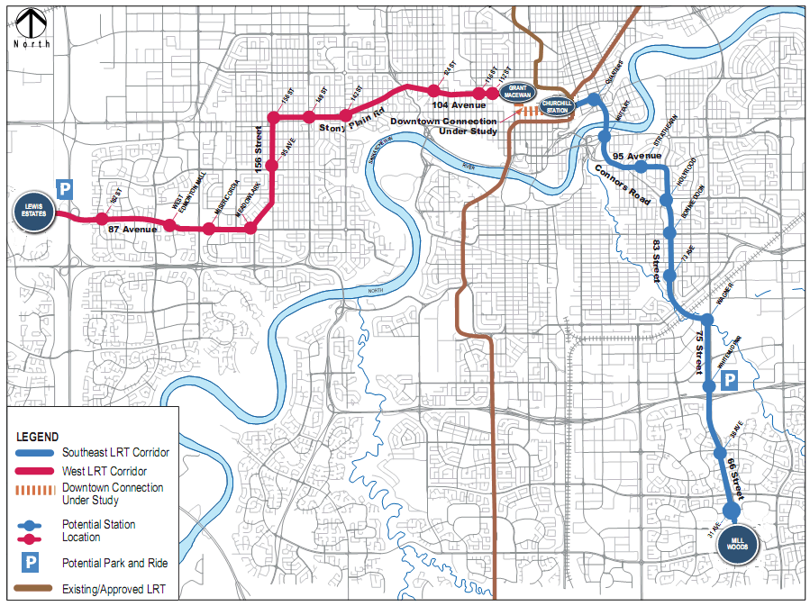
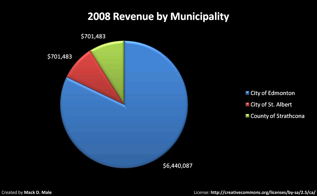
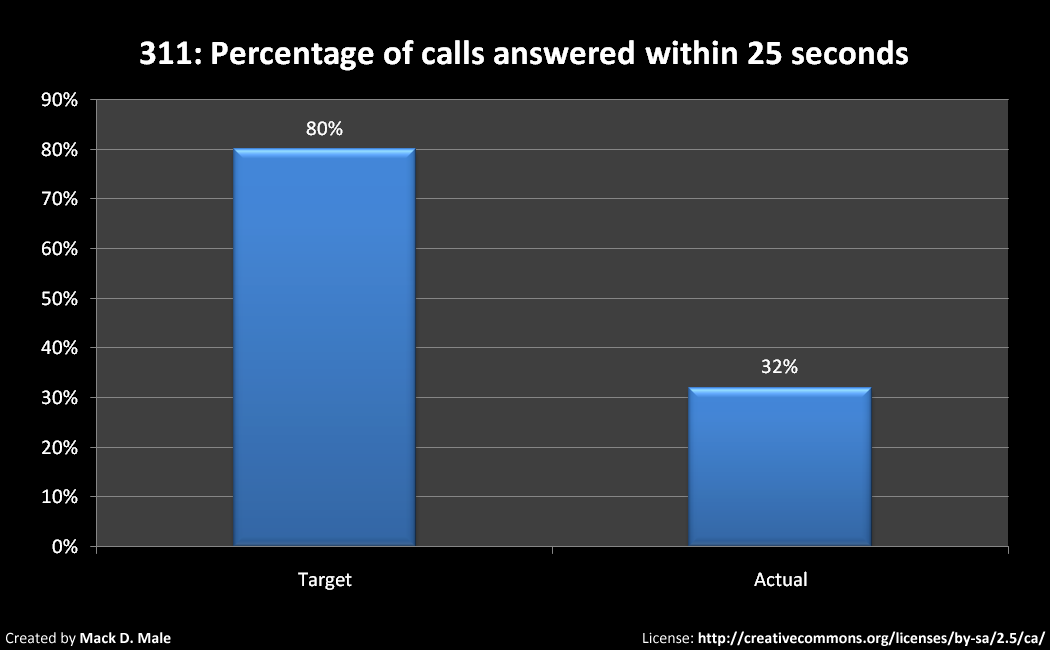
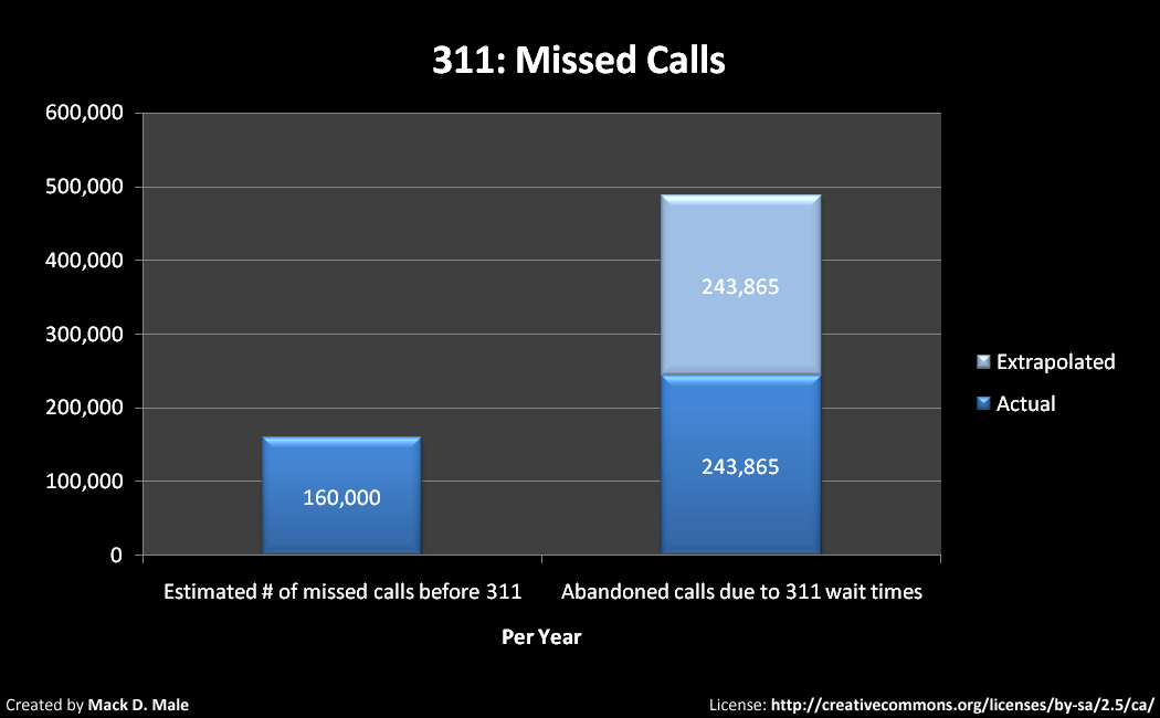
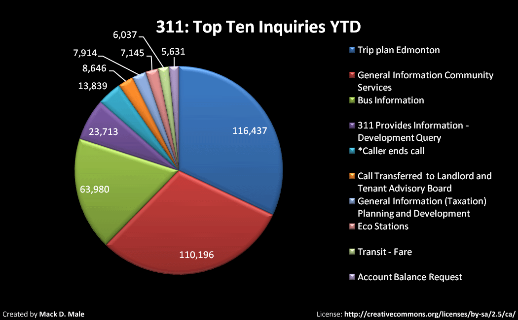
Last month, the City of Edmonton’s Office of the City Auditor completed a review of the Universal Transit Pass (U-Pass) pilot program (PDF). They found that although costs for the program rose, ridership has increased. I took a look at the report, and thought I’d share some of the more interesting facts and figures from it.

For those of you new to U-Pass: it’s a partnership between Edmonton Transit (ETS), St. Albert Transit (StAT), and Strathcona County Transit to provide a universal transit pass to eligible students at the University of Alberta and MacEwan. The current pilot started in the fall of 2007 and will finish up in the fall of 2010.

A total of 84,954 students were eligible in 2008 (counting both the Fall & Winter terms). Here’s the breakdown:

Here’s the revenue that each municipality received in 2008 (the City of Edmonton receives 84%, and the other two each receive 8%):

As the report was created by and for the City of Edmonton, it’s not known what, if any, service changes were made by St. Albert Transit or Strathcona County Transit (unless they too have a report somewhere). ETS made the following changes:

  • 437 service hours were added
  • 3 new routes were added
  • 19 more buses were put into service

Again, we only know the costs for the City of Edmonton. Here are the key figures for 2008:

  • U-Pass Sticker Production costs were $14,500
  • U-Pass Advertising and Promotion costs were $2,928
  • The opportunity cost of the U-Pass program, which is the loss of other ETS fare revenue, was estimated at $10,480,846
  • The cost of providing extra bus service hours was $2,571,221

Add it all up, and you get a total cost of $13,069,495. For the U-Pass program to break even, a fee of $155 per student per term would be required (up from the current $94.50).

In the Edmonton Journal, Councillor Krushell said that ridership nearly doubled from 2006 to 2008, from 7.3 million trips to 13.9 million trips. I’m not exactly sure where she got those numbers, because they aren’t in the report. What is in the report are Campus Passenger Boardings:

As you can see, boardings increased by 21,353 or 12.7% from 2006 to 2008. The report notes that some of this increase may have been caused by factors other than the U-Pass. Other non-financial positives include:

  • An 8% decrease in student parking permits at the University of Alberta since 2006
  • A greater than 8% drop in monthly parking passes at MacEwan for 2007 over 2006

And of course, there has likely been a positive impact on the environment with fewer students driving.

What’s next for the U-Pass?

Although NAIT students initially rejected the program in 2007, a recent survey indicated that a majority would now be interested in joining. The NAIT Students Association hopes to hold a referendum on the issue early next year. The expansion of the LRT to NAIT will no doubt have an impact on interest. If approved, NAIT could join the program for the 2010-2011 school year.

I suspect the program will continue after the current agreement ends, though it is likely that U-Pass fees will rise. Watch for news on a new agreement early next year – the U of A will be holding a student referendum in March to approve new fees, according to The Journal.

Highlights from the Alberta High Speed Rail report

Yesterday the Alberta government released a report assessing the potential for high speed rail service in the Calgary-Edmonton corridor. The report, which has been sitting on the shelf for about a year, was commissioned by the province and was prepared by Transportation Economics & Management Systems, Inc. (or TEMS). There are actually three parts to the report, which you can download here:

The press release included a few highlights, but nothing incredibly satisfying:

  • Nearly 10 million passenger trips took place in the Calgary-Edmonton corridor in 2006, with the breakdown as follows: 91% were by automobile, 6% were by air, and 3% were by bus.
  • The faster the high speed train, the greater the ridership and revenues.
  • People said they were willing to pay fares ranging from $56 to $120 for a one-way trip. (To compare: the lowest fare in the next month on WestJet currently is $99, or by car I can make the trip on about $20 of gas.)

I decided to dig into the report a little further. I was struck initially by the numerical nature of it – if numbers and formulas scare you, avoid reading the report. There is some useful, easy-to-understand data as well though.

The diagram above illustrates the Calgary-Edmonton corridor, and the five stations that would be part of the high speed rail system: Downtown Edmonton, Suburban Edmonton, Red Deer, Suburban Calgary, and Downtown Calgary. Each of the three major centres is called a “super zone”, and includes the surrounding communities, at least for the purposes of the report.

The images above illustrate the four types of generic train technologies used to represent various technology classes.

  • Talgo – 125 mph or 200 km/hr – diesel
  • JetTrain – 150 mph or 240 km/hr – turbine electric
  • TGV – 200 mph or 320 km/hr – overhead electric
  • Maglev – 300 mph or 480 km/hr – magnetic levitation

According to Wikipedia, the fastest conventional train in the world is the French TGV which set a speed record of 574.8 km/hr. The fastest non-conventional train in the world is the Japanese JR-Maglev which set a speed record of 581 km/hr.

This table outlines the strategies/predictions for each of the above:

  125 mph 150 mph 200 mph 300 mph
Average travel time (h:min) 2:00 1:45 1:35 1:00
Frequency (roundtrips/day) 8 10 14 17
Fare (in cents/mile) 25 35 40 60
Maximum fare one-way (Calgary-Edmonton) $56 $80 $90 $120
Maximum fare one-way from Red Deer $28 $40 $45 $60
Ridership (in thousands) in 2051 2821 4301 7656 10745
Passenger revenues (in millions of 2006 $) in 2051 137.1 269.0 610.0 1127.9
Market share (2011-2051 is constant) 1.85% 3.10% 4.84% 6.73%

Some other data points:

  • Demand for travel in the corridor is predicted to triple in the time period 2006-2051.
  • Total benefits by super zone are as follows: Calgary (40-45%), Edmonton (30-35%), Red Deer (20-25%)
  • Economic impact from building the system would range from $4.6 billion to $33.4 billion, depending on the type of technology used.
  • Growth in the economy of 0.2 to 0.5 percent, depending on the type of technology used.
  • Between 3400 and 7162 long-term (40 year) jobs would be created across the province.

There’s a lot more data available in the report if you want to take the time to read it.

What’s next? The government says it will continue to look at various options for the province’s future transportation needs, including high speed rail. No decisions have been made at this time, and the report itself makes no recommendations. There doesn’t seem to be a lot of support for the idea at the moment.

I personally think if the province is going to be spending money on transit, it should be on city and regional transit. Both Edmonton and Calgary could use the assistance to improve their respective transit systems – something akin to MoveOntario 2020 and Toronto’s Transit City.

This issue certainly has legs, however. It has been brought up and discussed many times over the years. You can follow along and participate on Twitter using the hashtag #abhsr. For more general Alberta political topics, use #ableg. There’s some great commentary up on the stream already.

Peter Newman in Edmonton discussing Resilient Cities

Author Peter Newman, in town this week for ICLEI World Congress 2009, gave a free talk tonight at the Shaw Conference Centre on some of the central ideas of the book he recently co-authored, Resilient Cities: Responding to the Crash, Climate Change, and Peak Oil. Presented by Edmonton on the Edge, the talk was hopeful in tone – a nice way to end ICLEI.

Here’s the handbill description:

A new approach to urban development needs to be forged that can, at the same time, enable cities to respond to the deep challenge of decarbonising cities and can use the transition to accelerate the development of what the UN calls the Global Green New Deal. Some hopeful directions will be outlined based on cities from around the world, including cities from down under.

Peter Newman in Edmonton

Peter is from Perth, Australia and he started by saying that Perth and Edmonton are similar in a number of ways (population, land distribution, etc). He next touched on Peak Oil (which Peter says happened in 2008) and the global recession. Peter positioned the Crash as an opportunity (his approach reminded me a lot of Ray Kurzweil). Peter showed a slide with five major economic downturns from the last 300 years or so, and pointed out the technological advances that were made after each. The rate of advance became faster over time, so that today we have exponential progress (this is essentially Kurzweil’s Law of Accelerating Returns).

My favorite part of the talk took the bulk of the remaining time – examples, complete with pictures, of cities around the world that have become Smart and Sustainable (together, the two characteristics of cities of the future, according to Peter). A couple of examples:

  • Phoenix, one of the worst cities in the world in terms of transportation by transit, recently replaced two lanes of traffic running through the centre of the city with light rail transit. Peter said if Phoenix can do it, anyone can!
  • Perth has completed significant rail developments in the last 15 years, with some lines going as far as 80km away from the core. During that time, ridership increased from 7 million passengers/year to 90 million/year. Amazing.

Peter introduced a number of acronyms during his talk:

  • IT: Information Technology
  • ET: Environmental Technology
  • TOD: Transit Oriented Development
  • POD: Pedestrian Oriented Development
  • GOD: Green Oriented Development

Naturally, IT and ET go together and TOD, POD, and GOD go together. You can’t have one without the others!

Peter Newman in Edmonton

Peter made reference to the concept of “place based cities” a few times, but unfortunately didn’t elaborate. The general idea is that you can make the local economy more viable by creating a stronger sense of place. Something about it really resonates with me.

The talk was followed by a reception, featuring music by Melissa Majeau. A number of other organizations helped Edmonton on the Edge make tonight’s talk possible, including the City-Region Studies Centre, University of Alberta Faculty of Extension, Edmonton Design Committee, ISL Engineering and Land Services, The City of Edmonton, and M.A.D.E. in Edmonton. Great event!

Recap: TransitCamp Edmonton

On Saturday, May 30th we held the first ever TransitCamp here in Edmonton. Overall I’d say it was a success, though it didn’t quite turn out the way I had expected! I guess that’s the way it goes with unconferences. We had about 50 people in attendance, and my primary goal of getting a group of interested citizens together with ETS to talk about transit was achieved. Most people I had a chance to talk to after said they enjoyed the event, which was great to hear.

The main issue was that we didn’t have Internet access at the World Trade Centre, despite being promised connectivity when we negotiated the space. We had a few other options (AirCard from Chris, going down to the ETS offices in Scotia Place) but they resulted in confusion more than anything. In the end we decided to cancel the two Skype sessions, which was really unfortunate but allowed us to continue.

During the confusion, however, something really interesting happened. People just started sharing and talking in little groups! It was great to see such conversations taking place, and I suppose the lesson is that they probably wouldn’t have if everything had gone according to plan.

The sessions were all great, I thought. Chris Moore started things off with an interactive discussion about Edmonton Transit IT, examining what we have now, what we’ll have if nothing changes, and what we could have if we consider some possibilities. Next up was Rhonda Toohey, who shared with us the 100 Year LRT Expansion Plan that will go before council on June 2nd. We had two ETS Platinum Bus tours with Dennis Nowicki, and everyone seemed quite impressed with the high tech buses. Brendan Van Alstine led a discussion about TRUE. I shared my presentation on Data for Developers – software developers, not land developers! Councillor Iveson finished the day off talking about “Selling Transit”, using Toronto’s Transit City (which is what Adam Giambrone was scheduled to present) as an example of a successful sell. Throughout the day we had a whiteboard where anyone could write down a question, and we answered most of them during the wrap-up session.

I’ll be working to update the TransitCamp Edmonton site with slides, resources, and more information over the next couple weeks. Be sure to check out Alain’s post on the event, and the iNews880 coverage also. Sharon took a few photos during the day, which you can see here. Eugene posted some photos here, and Grant recorded some video that you can watch here.

Thanks to everyone who came out to TransitCamp, and a special shout-out to the three who came up from Calgary! I hope we’re able to do it again soon (in a venue with Internet) – though maybe in a different format. Let me know if you have any feedback, suggestions, or other ideas!