Back in May I attended the first open house for the Jasper Avenue New Vision project, an initiative that seeks to re-establish Jasper Avenue as the main street of Edmonton. Tonight another open house was held at Enterprise Square downtown, to provide an update on the project and a lot more detail on the plans and designs. Like last time, there were large posters, a 3D foam model, and a presentation. This time however, the presentation was much more in-depth.


Mark Reid of Urban Strategies hosted once again, and began by stressing that the New Vision project is about more than just the streetscape. It takes into consideration the adjacent streets, and is really about targeting re-investment to strengthen downtown’s economic advantage. Much of the presentation focused on the six “big moves”:
- Re-vision Jasper Avenue: A catalyst for downtown investment
- Civic and Cultural Riverfront Centre
- Veterans Park Intensification Area
- Capitol District Intensification
- Warehouse Community
- Railtown Centre
The first big move is to make Jasper Avenue the signature street in Edmonton, reflecting the vibrancy and diversity of the city. Some of the key principles the team has used include: Place Making, The Streetscape, Prioritize Transit/Pedestrian Use, Built Form, Winter City, Activate Ground Floors, Residential Focus, Sustainability, Leadership & Commitment.
The key recommendation for Jasper Avenue is related to space. Currently the street is 30m wide, 21.8m of which is devoted to paved lanes, and 8.2m of which is devoted to sidewalks (4.1m on either side). Essentially 75% of Jasper Avenue is for cars and buses – 4 thru lanes, 2 parking/transit lanes, and 1 turn lane. The plan is to reduce that to 60% – 2 thru lanes, 2 thru/transit/parking lanes, and 1 turn lane, resulting in 17.6m for paved lanes and 6.2m of sidewalk on either side. There would be no parking during rush hour, and only two lay-bys would remain (the space for buses to park on the side). Additionally, the curb lane would be wider to help facilitate transit and cyclists. Traffic volume statistics show that the roadways that run parallel to Jasper Avenue are very underutilized, so there appears to be capacity for this reconfiguration to work.

Jasper Avenue and 106th Street, facing northwest
Another set of recommendations are related to the streetscape. I noted a few main ideas:
- Larger trees, by increasing the amount of soil available for each tree by 5 times. In addition to playing a visual role, the trees are an important part of storm water removal.
- A “grander” looking sidewalk, with steel-faced curbs to reduce the damage caused by winter snow removal, among other things.
- Heated sidewalks, powered by a glycol system that would pipe waste heat from buildings through the sidewalks. The idea is that Jasper Avenue sidewalks would never need to be shoveled, sanded, or salted ever again!
- Four scramble intersections, tentatively located at 99th Street, 100th Street, 105th Street, and 108th Street.
- Newspaper boxes, seating, and other “clutter” would largely move to side streets, keeping Jasper Avenue clean looking. With the removal of lay-bys, you would have a mostly clear, straight sight-line down the Avenue.
There are also recommendations for the appearance of buildings along Jasper Avenue. The team has identified four main categories:
- 13% of the facades are heritage buildings or contribute positively.
- 18% require some sort of major retrofit.
- 32% of the facades are candidates for redevelopment.
- 37% require some sort of minor retrofit.
These are all part of the Urban Design Framework, a document that itself will form part of the Capital City Downtown Plan.

Jasper Avenue & 105th Street, facing northeast
Less time was spent on the other “big moves”, I think because the presenters were running out of time! In the study area today, there are just 2.6 hectares of municipally-owned park space, which is about 3% of the total space. A key target is to increase that to 8%, which is what the Veterans Park Intensification and the Civic and Cultural Riverfront Centre moves are aimed at. Some of the key ideas include:
- The creation of “MacDonald Central Park” in front of Hotel MacDonald (Mark cited Bryant Park in New York as an example). The park would link up to the “Riverfront Heritage Trail” behind the hotel, which in turn would connect with Veterans Park.
- The introduction of “mews” throughout downtown – pedestrian-only streets, essentially.
- Expanding and improving Beaver Hills House Park, as part of the proposed Warehouse Community.
Overall the ideas presented are quite exciting, and when Mark asked for a show of hands indicating support, nearly everyone raised their arm.
In total, the plans call for an increase of:
- 8,300,793 GSF of residential space
- 1,173,454 GSF of office space
- 656,487 GSF of retail space
Which if implemented today, would result in a $19 million increase in tax revenues.
The big question, of course, is how much this will cost and when it’ll happen. Mark said costing information will come in the next phase (winter 2010), which also includes preliminary streetscape and engineering designs, and a finalized urban design framework. Some of the work will happen anyway, though. The trolley wires are scheduled to be removed, and Central LRT station is in need of renovations due to water leaks, work that is tentatively scheduled for 2012. Beyond that, no details were provided.
A lot of information was presented this evening, and I’m not sure I’ve done it justice here. It’s one thing to read about the recommendations, and quite another to see the detailed diagrams and other artwork. I really wish they’d update the website with more information and visuals!
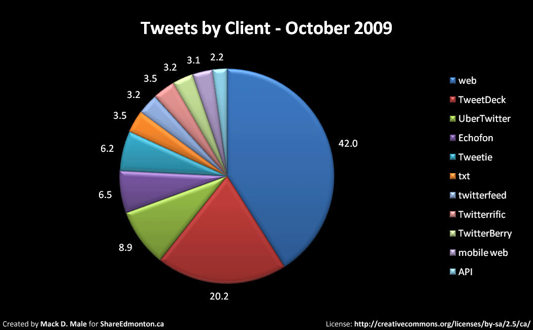
 Welcome to the tenth State of the Edmonton Twittersphere, my look at the intersection of Twitter and Edmonton. You can
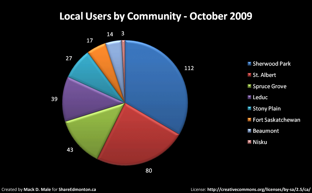


 In the grand scheme of things, the City of Edmonton could be considered an early adopter of social media tools. They’ve been
  I’m encouraged by the progress that is being made on making open data a reality here in Edmonton. I think the
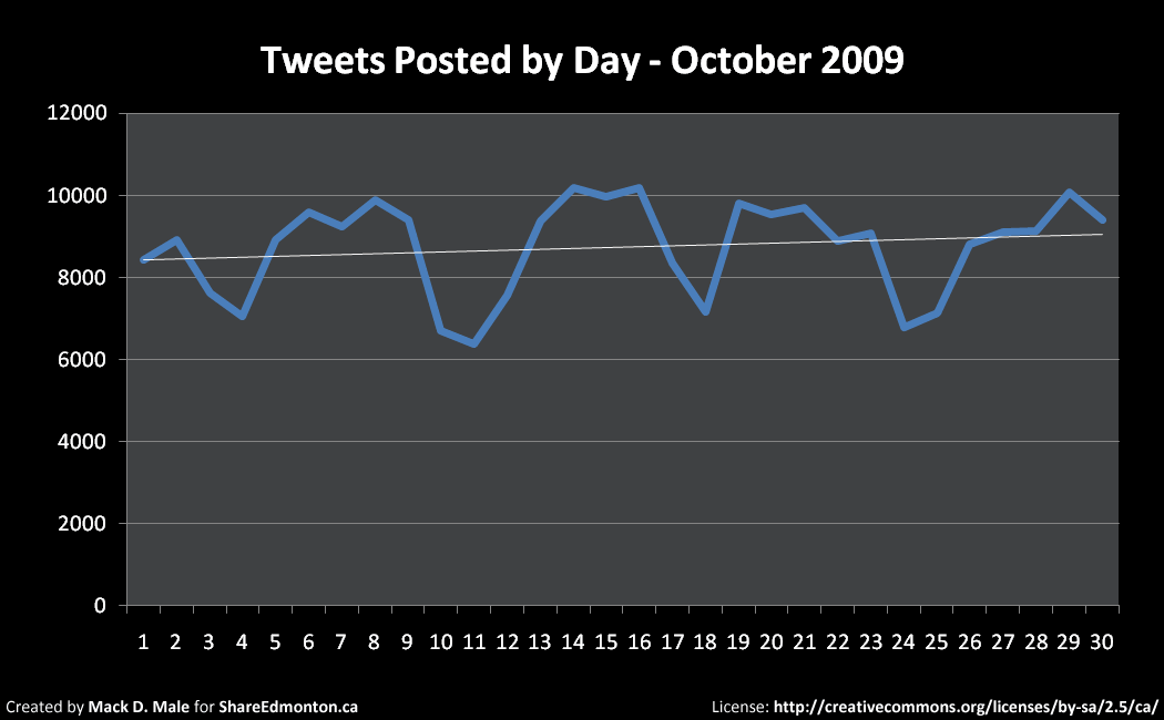


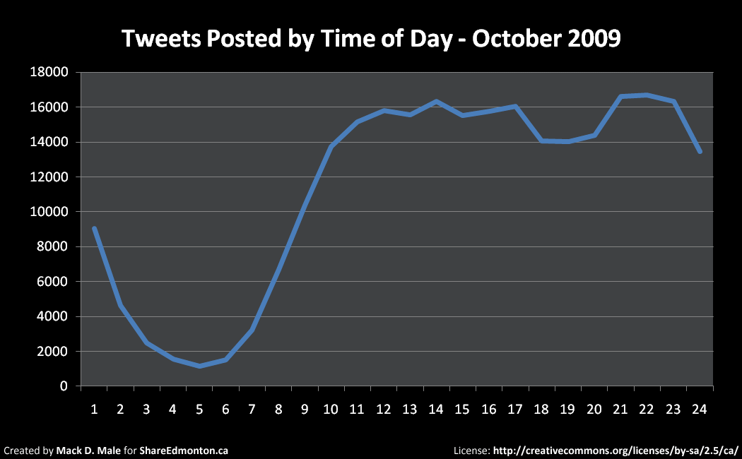
 As you are undoubtedly aware,