 Yesterday the Government of Canada launched its open data portal at data.gc.ca. Open Data is one of three Open Government Initiatives, the other two being Open Information and Open Dialogue. Stockwell Day, President of the Treasury Board and Minister for the Asia-Pacific Gateway, issued a statement today on the launch:
“Today, I am pleased to announce the next step in our government’s commitment to enhancing transparency and accountability to Canadians. The expansion of open government will give Canadians the opportunity to access public information in more useful and readable formats, enable greater insight into the inner workings of the Government and empower citizens to participate more directly in the decision-making process.”
He goes on in the statement to say that Canada has historically led the way in providing information to citizens. Lately though, we’ve definitely fallen behind. I’m glad to see us moving forward once again. This development is no doubt the result of lots of work by many passionate Canadians, such as David Eaves. Here’s what he posted yesterday:
The launch of data.gc.ca is an important first step. It gives those of us interested in open data and open government a vehicle by which to get more data open and improve the accountability, transparency as well as business and social innovation.
David does a good job in that post of highlighting some of the issues the site currently faces, such as some problematic wording in the licensing, so I won’t repeat that here. Instead, I figured I’d do what I always do when I get new datasets to play with – make some charts!
The open data portal says there are 261,077 datasets currently available. Just 781 of those are “general” datasets, the rest are geospatial. That’s an impressive number of geospatial datasets, but they are somewhat less accessible (and perhaps less interesting) to the average Canadian than the general datasets. It looks like you need to be able to work with an ESRI Shape File to use most of them.
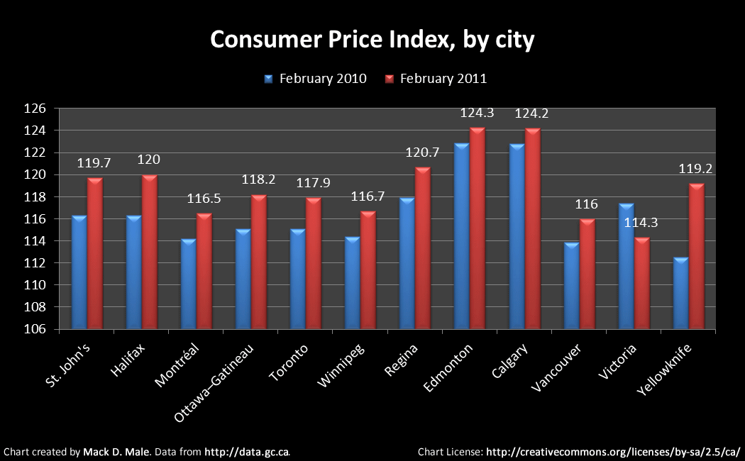
There are lots of general datasets you might find interesting, however. For example, here’s the Consumer Price Index by city:
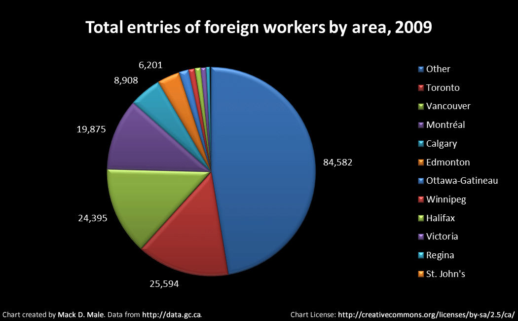
Here’s another dataset I thought was interesting – the number of foreign workers that have entered Canada, by region:
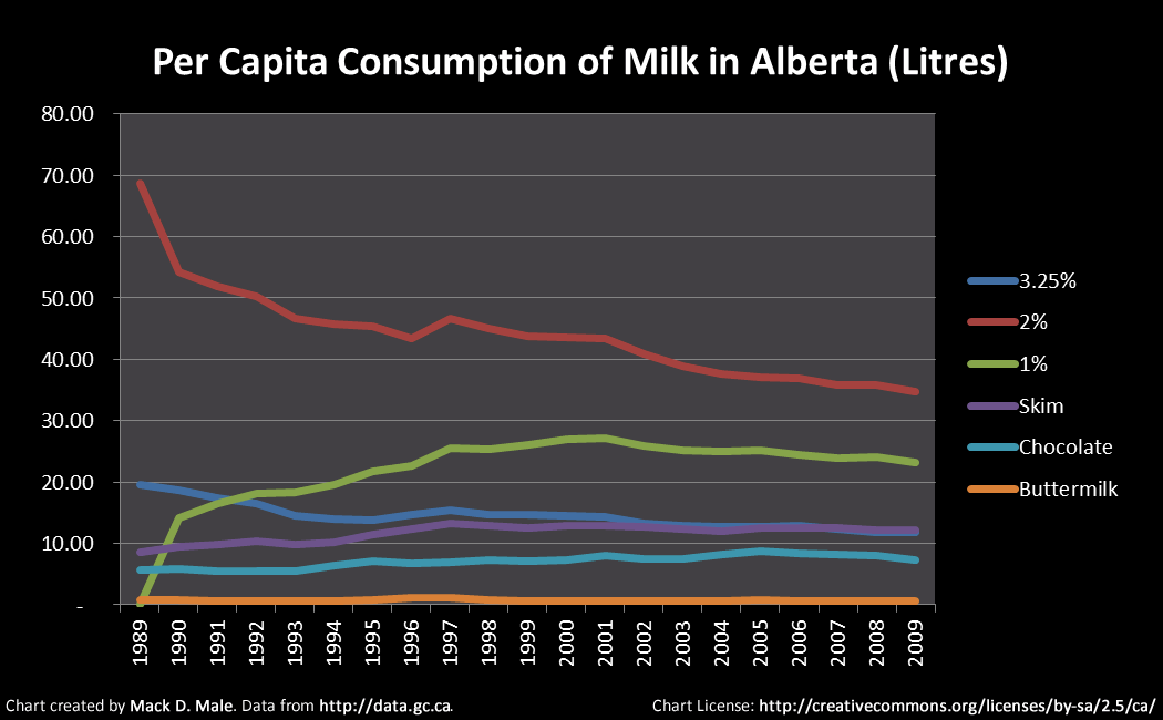
Have you ever wondered how much of each type of milk Albertans consume? You can find that out:
There’s actually a fairly broad range of datasets available, such as weather, agriculture, economics, and much more. As David said, it’s a good first step.
I’m excited to see more ministries get involved, and I hope to see the number of datasets available increase over time. I’d also love to see the licensing change, perhaps by adopting the UK Open Government License as David suggested. Exciting times ahead!

Mack, there are three significant classes of data that I feel are important:
1. The Statistics Canada Data has been released. These data include health indicators (such as diabetes prevalence by demographic), population data and economic data (such as median family income by provence). This is significant as (1) Stats Can has given up their revenue model in support of open data, and (2) the data is searchable and *much* easier to find.
2. The spatial data sets includes the entire National Topographic Survey 1:50 000 and 1:250 000 map set. These are the famous topo maps, and are available as a .TIFF (geolocated) and .JPEG. I think that this is cool as it allows the user to load their map of choice into iPhoto, photoshop or any other editor (PowerPoint) and crop to the section of the map that they need and print it off. . I have already done this for a course, and can imagine that I will do it for hiking trip or other trips to the mountains. The digital NTS map set usually sells for $100, and is now available for free. Map Town will be taking a hit on this…
3. The spatial data sets really make the Stats Can data shine as you can load and merge the data sets in the ESRI ArcGIS and do some really cool things. The downside is that the ESRI products are not user friendly and expensive to license. But, ESRI applications are not the only apps that can view ESRI files. Refractions Research, for instance, has a free and easy to use GIS Data viewer called uDig that allows anyone with the interest to view shape files. uDig can be downloaded here: http://udig.refractions.net/.
My thoughts.
Thanks for your thoughts and the pointer to uDig, I’ll definitely be checking that out! I agree that the inclusion of Statistics Canada data is a big deal.
If you are looking for some more powerful GIS tools, QGIS is apparently good, and I have seen many maps made in ‘R’. R is free and way more powerful than uDig, and is script based which might suite you :).
And I just paid for some Stats Can data!
Thanks for the blog.
nice find – thanks I was curious when i first heard about this… local initiatives seem to be still searching for direction…