The City of Edmonton officially announced today its intention to annex a large area south of our current boundaries (you can listen to the press conference here). The plan would see 120 km2 west of the QEII highway annexed, an area which includes the Edmonton International Airport, and about 36 km2 east of the QEII annexed, which would include most of the area between Edmonton and Beaumont. According to Mayor Mandel, the new space would be used for both residential and industrial development. You can read much more about the news here, and be sure to check out the City’s page on the proposed annexation. It is estimated that the annexation could be completed in as little as two years. You won’t be surprised to hear that I’m less than enthusiastic about the news.
Edmonton’s Annexations
I’ll write more about that specific proposal in the future, but for now I thought it would be useful to take a look at Edmonton’s previous annexations. I have included the proposed annexation in the data below however, to give you a sense of where it fits in (I went with 2015 as the year). There have thus far been 31 annexation events in Edmonton’s history, according to a document prepared by the City’s planning department. That includes the incorporations of both Edmonton and Strathcona, as well as three temporary separations. Most of those annexations were relatively small, with an average annexation area of about 21 km2. Take out the 1982 annexation however, and the average drops to just 10 km2.
Here’s what those annexation events look like on a chart:
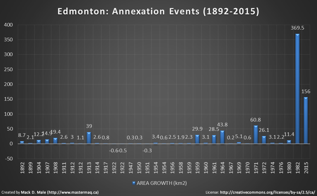
As you can see, the annexation in 1982 was unusually large – it doubled the size of our city. The proposed annexation in the south would handily come in as the second largest annexation in Edmonton’s history.
Here’s the list of annexation events:
| YEAR | DESCRIPTION | CUMULATIVE AREA (km2) |
| 1892 | Incorporation of Town of Edmonton | 8.7 |
| 1899 | Incorporation of Town of Strathcona | 10.8 |
| 1904 | Incorporation of City of Edmonton | 23.0 |
| 1907 | Incorporation of City of Strathcona | 37.9 |
| 1908 | Buena Vista to Westmount, North Inglewood to Eastwood/Virginia Park | 57.3 |
| 1911 | Highlands, Amalgamation of Edmonton & Strathcona | 59.9 |
| 1912 | Belmont Park | 62.9 |
| 1912 | Kennedale | 64.0 |
| 1913 | Dominion Industrial to Quesnell Heights / Brander Gardens to Parkallen, Bonaventure to Belvedere, Forest Heights to Argyll | 103.0 |
| 1914 | Allendale / Duggan to Coronet / Papaschase | 105.6 |
| 1917 | Calder | 106.4 |
| 1922 | Separation of north Brander Gardens | 105.8 |
| 1922 | Separation of Papaschase | 105.3 |
| 1947 | Pleasantview | 105.6 |
| 1950 | Whitemud Creek | 105.9 |
| 1951 | Separation of part of Duggan | 105.6 |
| 1954 | Capilano / Fulton Place | 109.0 |
| 1954 | Coronet | 109.6 |
| 1956 | Gold Bar | 112.1 |
| 1958 | Davies Industrial | 114.0 |
| 1959 | Terrace Heights / Ottewell | 116.3 |
| 1959 | Terwillegar Park / Riverbend to Strathcona Industrial Park, re-annexation of separations | 146.2 |
| 1960 | Ottewell to Girard Industrial | 149.3 |
| 1961 | Beverly / Clareview to Dickinsfield | 177.8 |
| 1964 | Jasper Place and Southeast Industrial | 221.6 |
| 1967 | Clover Bar Power Plant | 221.8 |
| 1969 | Springfield / Callingwood | 226.9 |
| 1970 | Springfield – north | 227.5 |
| 1971 | Castle Downs / Lake District and Mill Woods | 288.3 |
| 1972 | West Jasper Place | 314.4 |
| 1974 | Kaskitayo | 317.5 |
| 1976 | Northwest Industrial | 319.7 |
| 1980 | Pilot Sound and Twin Brooks | 331.1 |
| 1982 | Northeast, Southeast, Southwest Urban Growth Areas | 700.6 |
| 2015 | Proposed South Annexation | 856.6 |
Municipalities annex land for a variety of reasons – sometimes the goal is to acquire industrial land, other times its to start developing future residential neighbourhoods. Here’s what our land and population growth has looked like over the last 120 years:
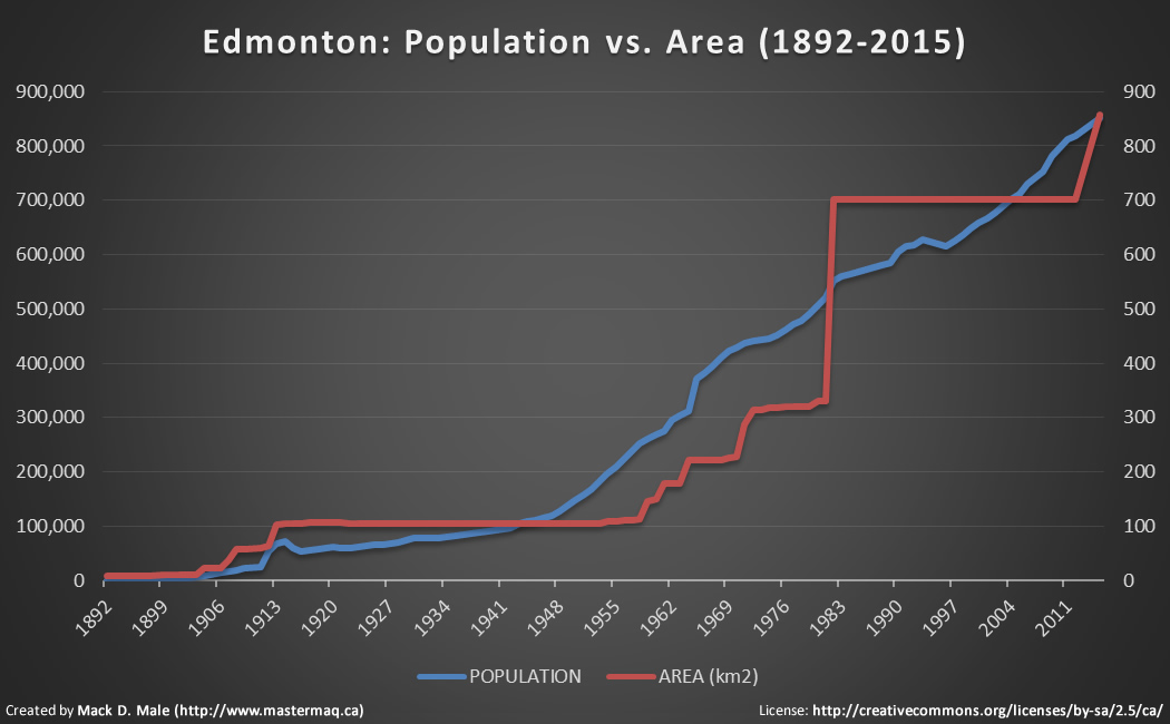
The left axis and blue line shows the growth in Edmonton’s population, while the right axis and red line shows the growth in Edmonton’s land area. While our population has risen steadily, annexations have been much less consistent.
Impact on Population Density
When the Town of Edmonton was incorporated in 1892 it consisted of 8.7 km2 of land and was home to about 700 people, giving us a population density of about 81/km2. Today, with a population of nearly 818,000 and a total area of about 700 km2, we have a much higher population density of roughly 1,167/km2. That’s not the highest it has ever been, however. Edmonton’s population density peaked in 1958 at about 2,212 people/km2 and has been falling ever since.
(For comparison purposes, New York City’s population density is 10,430/km2, London’s is 5,206/km2, Toronto’s is 4,149/km2, Vancouver’s is 5,249/km2, and Calgary’s is 1,329/km2. Yes, even sprawling Calgary has a higher population density than us!)
Here’s what our population density looks like on a chart:
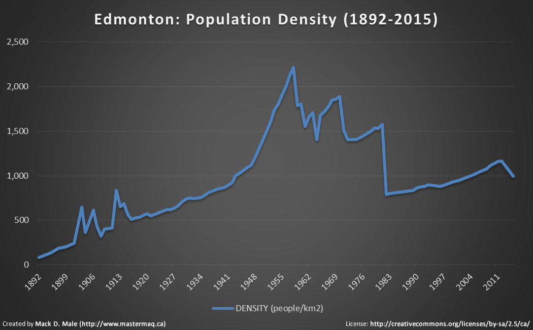
There are a couple of key events to point out. The amalgamation of Edmonton and Strathcona in 1912 is noticeable thanks to a jump in the population. The annexations in 1959 of Terrace Heights, Ottewell, Terwillegar Park, and Riverbend marked the start of our population density decline. The jump back up in 1964/1965 was due to the annexation of Jasper Place, which brought about 38,000 residents to Edmonton in addition to more space. The large drop in 1982 is extremely apparent, and while the population density has slowly been creeping back up, you can see that the proposed annexation would cause it to decline once again.
Looking at the Capital Region
I absolutely agree with Mayor Mandel that a strong Edmonton is a strong region, but I don’t necessarily agree that Edmonton needs to acquire more land in order to remain strong. Supporters of annexation may suggest that Edmonton’s declining proportion of the region’s population is proof that buyers are not finding what they’re looking for within the city so they’re going elsewhere.
Here’s a look at the percentage of people in the Edmonton CMA who live within the city limits:
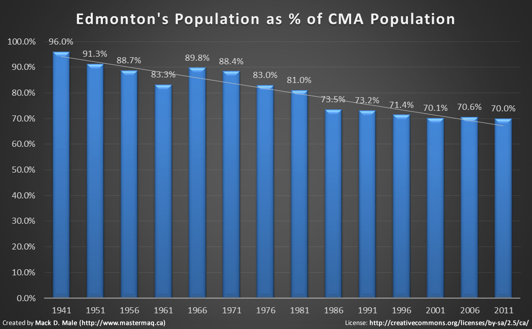
What’s clear is that there has been a decline in the proportion of people living in Edmonton-proper versus the surrounding areas. What’s less clear is why that has happened.
While Edmonton has not annexed any land since 1982, there have been 6 annexations by other municipalities in the region in the last 15 years.
Other Resources
Annexation is a big topic. Here are some additional resources that you may find useful:

So what are the incentives for a city to increase density? I understand (somewhat intuitively) that there are benefits to be experienced once you have the density, but is it even possible to weigh them with the costs?
It’s Canada. We have more room than we know what to do with. It seems somewhat beneficial to take advantage of that.
Edmonton has more than 4600 km of roads, more than 3800 km of water mains, and billions of dollars worth of other assets to maintain. Every time we expand into a new area, we disproportionately increase the cost of maintaining all that infrastructure. Unless something changes on the revenue side, it’s not sustainable.
denser places are more productive & efficient than diffuse places.
Our traffic levels are fairly reasonable in Edmonton, but if we put hundreds of thousands of people really far from the core, it’ll increase traffic/road development costs. It’s pretty pertinent, because we don’t really have a ton of budget to put into developing that much infrastructure. Unless the price of oil skyrockets, we can’t afford that kind of development.
Really cool, thanks for the perspective!
Great analysis as always Mack. Just wanted to point out that in fact our new suburbs are being built denser than Calgary’s. It’s also interesting to note that our new suburbs are almost twice as dense a some existing mature neighbourhoods (Westmount for example). (sorry I don’t have actual numbers right in front of me at the moment)
Conclusion? Spend more on mature neighbourhoods and make it easier to attract appropriate infill projects.
I wouldn’t necessarily use density in the case of annexations. You could argue that Edmonton is significantly denser than Ottawa if we left it to arbitrary definitions of what exactly is a municipality. I would suggest comparing dot density maps (atlas of suburbanisms provides great examples) to get a more accurate comparison of a region’s density.
As always, an excellent read & analysis!
Thanks!
If Edmonton is worried about where to put people, it can start to look up, and split some of those larger single-family home lots.
If Edmonton is worried about the increasing number of people living outside of the city limits that tax its services, it can grab a lot of that cost back in tolls. That would also force bedroom communities to tax more realistically for their own services and/or create stronger business communities to keep people at home.
Annexing land without seriously considering density and the relationship with surrounding communities does nothing but continue the same old. Sprawing and sprawling since ’59!
this is something interesting. Edmonton is a big area. i just hope it is more beneficial to all who live there Beefjerky.com Free Delivery
a couple of errors in the analysis; me thinks the 1982, 2015 square kilometers have not been calculated correctly. the landscape, land forms in Edmonton are a tad different than Calgary’s not certain you can compare them well. as for New York and such – many annexations and amalgamations have taken place over time and the cost of housing is a tad expensive.
cumulative size of 700+ in 1982 is correct, my apologies