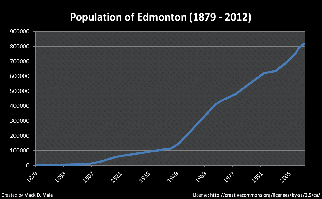
This morning the results of the 2012 Municipal Census were released, and Edmonton’s new official population is 817,498. That represents annual average growth of about 12,000 since 2009 when the last census was conducted.
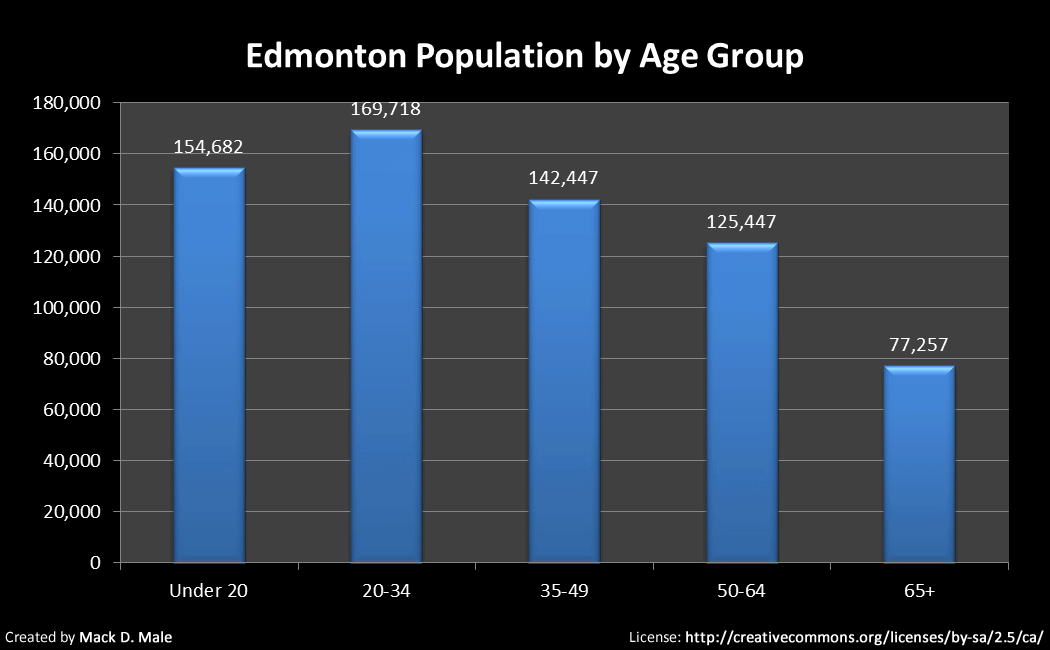
Mayor Mandel seized on the numbers related to age – the largest proportion of residents are in the 25-34 demographic (about 14.5%):
“The growth in population indicates that Edmonton is a city of opportunity,” said Mayor Stephen Mandel. “It is gratifying and exciting to know that so many young people are calling Edmonton their home. This reinforces the appeal of Edmonton, and the value of what our City has to offer; opportunity, culture and quality of life.”
Here’s what our growth curve looks like:
Here’s a look at the population by age group:
One of the new questions asked this year was about mode of transportation from home to work. The results are not incredibly surprising – roughly 80% of Edmontonians get to work by automobile:
![]()
You can see all of the results here, including PDFs for each ward and neighbourhood. Unfortunately I can’t do a detailed comparison by neighbourhood, because the open data catalogue has not been updated and I’m not going to sift through 375 PDFs to get the data I need. A note on the website reads: “2012 results will be added to the Open Data Catalogue in early August.” While I suppose it’s a positive that the data will in fact be uploaded to the catalogue, there’s absolutely no excuse for it not already be in there. I feel like I’m fighting the same fight, three years later.
I was most interested in Downtown however, so I did look at the PDF. The population increased far less than I had anticipated, rising to 12,199 from 11,572 (growth of about 5.4%). In other words, just 1.8% of the city-wide population growth occurred in the Downtown neighbourhood. Clearly we still have work to do (perhaps surrounding neighbourhoods grew more, will wait for the open data to analyze that).
Last year City Council passed a new Municipal Census Policy which states that a census will be conducted every two years starting in 2012. Throughout the month of April, census workers knocked on doors asking Edmontonians a variety of demographic questions. The results are important because many grants from other orders of government are calculated on a per capita basis. Additionally, the City needs updated numbers to effectively plan services, and to ensure ward boundaries result in fair representation by population.
The next Municipal Census will be held in April 2014.

One building can make a huge difference in the population data of downtown, but I’m guessing that other mature neighbourhood, save for Boyle, also grew at a slower rate than the suburbs. This is reflected in policy developed by current Council in “The Way We Grow” plan for only 25% of new growth in mature neighbourhoods.
The City should update the Open Data catalogue simply to make sure you have the best info possible for these kinds of updates. I see that as an important municipal duty.
It’s also amazing that the electronic data is put into a PDF but not the catalogue. Someone had to type that up. Now someone else will be paid to type it up again.
Last time they generated the PDFs from an Excel document. Still, there’s source data that could just as easily go into the catalogue!
I’d also be interested to know if many new buildings opened up downtown in the last year. I know there was a bigger jump into 2011 with the new buildings on 104 Street, so perhaps this was just the Census in the middle (with more homes likely to be reflected in the next round of data).
Do you know where to pull data on how the City’s size/area has changed? I have not been able to find it, but it would be interesting to know if with this population growth, the City is becoming overall less or more dense.
Hmm, good question. There’s not much historical data in the open data catalogue, so one would have to look elsewhere. I’ll give it some thought.
You can find this info here:
http://www.municipalaffairs.alberta.ca/cfml/MunicipalProfiles/
For Edmonton, the area is the same for 2007-2010 (no data for 2011) at 69,984 hectares.
Edmonton’s city limits have not changed since the last major annexation in 1982, when it more than doubled in size to the current 700.6 sq km, so technically density is proportional to population from that point on. However, this doesn’t account for developed vs undeveloped land, which is an entirely different kettle of fish. The city’s planning group may be able to shed some light on historical development patterns (farmland conversions to property).